Available with Image Analyst license.
A Capella synthetic aperture radar (SAR) image must be processed before it can be used for visualization or analysis. Issues to address include calibrating to retrieve a meaningful backscatter value, mitigating speckle, removing radiometric terrain distortions, and rendering images with a large value range.
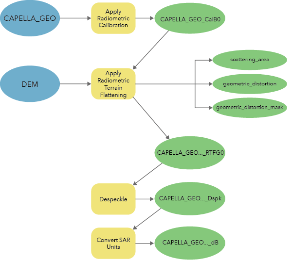
The Synthetic Aperture Radar toolset, in the Image Analyst toolbox, contains four tools you can use to generate calibrated, terrain-corrected, analysis-ready imagery data from Capella Geocoded Terrain Corrected (GEO) data. The following tools are used to generate analysis-ready Capella GEO data, as shown in the table and diagram below:
| Tool | Description |
|---|---|
|
Converts the input synthetic aperture radar (SAR) reflectivity into physical units of normalized backscatter by normalizing the reflectivity using a reference plane. | |
Corrects the input synthetic aperture radar (SAR) data for radiometric distortions due to topography. | |
Corrects the input synthetic aperture radar (SAR) data for speckle, which is a result of coherent illumination that resembles a grainy or salt and pepper effect. | |
Converts the scaling of the input synthetic aperture radar (SAR) data between amplitude and intensity, between linear and decibels (dB), and between complex and intensity. |

Capella GEO processing considerations
Capella auxiliary products provide a constant scaling factor to calibrate image values from digital numbers to sigma nought. Apply Radiometric Calibration uses a constant incidence angle value, provided in the Capella auxiliary products, to convert sigma nought values to beta nought or gamma nought values.
The Apply Geometric Terrain Correction tool is omitted from the Capella GEO workflow. Unlike Capella Geocoded Ellipsoid Corrected (GEC) products, Capella GEO products are already orthorectified using a digital elevation model.