In the geodatabase, attributes are managed in tables based on a series of simple, yet essential, relational data concepts:
- Tables contain rows.
- All rows in a table have the same fields.
- Each column has a data type, such as integer, decimal number, character, and date.
- Functions and operators are available to manage tables and their data elements.

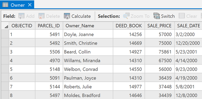
Tables and relationships play a key role in ArcGIS, just as they do in traditional database applications. Rows in tables can be used to store all the properties of geographic objects. This includes holding and managing feature geometry in a Shape column.
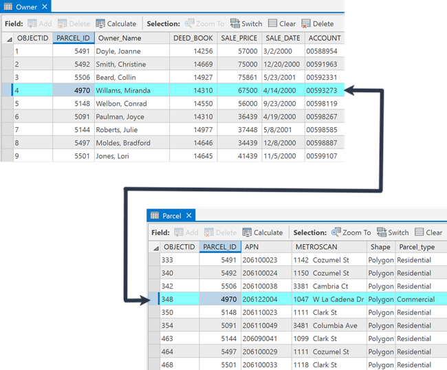
The illustration below shows two tables and how their records can be related to one another using a common field. The Owner table is related to the Parcel table through the PARCEL_ID field.

Attribute data types in the geodatabase
There are a number of supported attribute data types used to store and manage attributes in the geodatabase. The available data types include a variety of numerical types, text, date, binary large objects (Blob), and globally unique identifiers (GUIDs).
The supported attribute data types in the geodatabase include the following:
- Numbers—Can be one of the following numeric data types:
- Short—Short integers (16-bit)
- Long—Long integers (32-bit)
- Big integer—Big integers (64-bit)
- Float—Single-precision (32-bit) floating point numbers
- Double—Double-precision (64-bit) floating point numbers
- Text—Any set of alphanumeric characters of a specified length.
- Date—Can be one of the following date types:
- Date—Date and time values
- Date only—Date values only with no time values
- Time only—Time values only with no date values
- Timestamp offset—Date, time and offset from UTC value
- Blob—Binary large objects are used to store documents, photographs, or other large data.
- Global identifiers—Global ID and GUID data types store registry-style strings consisting of 36 characters enclosed in curly brackets. These strings uniquely identify a feature or table row within a geodatabase and across geodatabases. These are heavily used to manage relationships, especially for data management, versioning, change-only updates, and replication.
- Object ID—An object identifier is a unique, integer field that cannot have null values and is added when a geodatabase table or feature class is created in ArcGIS. This object ID field stores a unique ID for each row in the table and is created as a 32-bit object ID, by default. If object ID values need to be greater than 2.14 billion, the object ID field can be migrated to use 64-bit object IDs using the Migrate Object ID to 64 Bit geoprocessing tool.
See ArcGIS field data types for more information.
Extending tables
Tables provide descriptive information for features, rasters, and traditional attribute tables in the geodatabase. Users perform many traditional tabular and relational operations using tables.
In the geodatabase, there is a focused set of capabilities that are optionally used to extend the capabilities of tables. These include the following:
Working with attribute tables in the geodatabase
| Use | If you need to |
|---|---|
Specify a list of valid values or a range of valid values for attribute columns. Use domains to help ensure the integrity of attribute values. Domains are often used to enforce data classifications (such as road class, zoning codes, and land-use classifications). | |
Manage a set of attribute subclasses in a single table. This is often used on feature class tables to manage different behaviors on subsets of the same feature types. | |
Manage long update transactions, historical archives, and multiuser editing required in GIS workflows. |