NetCDF (network Common Data Form) is a file format designed to support the creation, access, and sharing of scientific data. It is used extensively in the atmospheric and oceanographic communities to store variables, such as temperature, pressure, wind speed, and wave height.
NetCDF data is as follows:
- Self-describing, meaning that a netCDF file includes information about the data it contains, such as when data elements were captured and what units of measurement were used.
- Portable, or cross-platform, in that a netCDF file created on one type of operating system can often be read by software on another type of operating system.
- Scalable, such that a small subset of a large netCDF file can be accessed efficiently without reading the entire file.

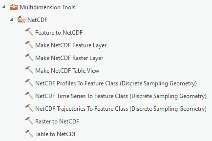
ArcGIS Pro reads netCDF files natively, providing immediate access to the data without the need for data conversion or import. You can use the Make NetCDF Raster Layer, Make NetCDF Feature Layer, Make NetCDF Table View, NetCDF Profiles To Feature Class (Discrete Sampling Geometry), NetCDF Time Series To Feature Class (Discrete Sampling Geometry), and NetCDF Trajectories To Feature Class (Discrete Sampling Geometry) tools from the NetCDF toolset in the Multidimension toolbox to create a raster layer, feature layer, table view, and feature classes from profiles, time series, and trajectories, respectively, from a netCDF file.
You can also create a raster layer from a netCDF file, using the Make Multidimensional Raster Layer tool from the Multidimension toolbox.
Following is the list of available tools for working with netCDF data.

You can also add a classic netCDF raster layer or a multidimensional raster layer using the Multidimensional Raster Layer  option in the drop-down list for the Add Data button
  . For more details, refer to Work with multidimensional raster data.