| Beschriftung | Erläuterung | Datentyp |
Eingabe-TIN | Das zu verarbeitende TIN-Dataset. | TIN Layer |
Ausgabe-Feature-Class | Die Feature-Class, die erstellt wird. | Feature Class |
Kantentyp (optional) | Die Dreieckskante, die exportiert wird.
| String |
Zusammenfassung
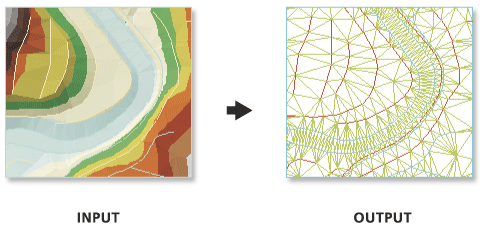
Erstellt 3D-Linien-Features mit den Dreieckskanten eines TIN-Datasets (Triangulated Irregular Network, trianguliertes unregelmäßiges Netzwerk).
Abbildung

Verwendung
Mit dem Parameter Kantentyp können Sie einen bestimmten Dreieckskantentyp extrahieren.
Das Ausgabe-Feature enthält ein Feld mit der Bezeichnung EdgeType, in dem der Kantentyp jeder Linie mit Ganzzahlwerten dargestellt wird:
- 0 – Eine reguläre Kante, also eine Kante, die nicht ausdrücklich als hart oder weich definiert wurde. Dieser Kantentyp wird durch Triangulation der TIN-Datenpunkte erzeugt.
- 1 – Eine weiche Kante, also eine Kante, die einen allmählichen Übergang in Neigungswerten darstellt.
- 2 – Eine harte Kante, also eine Kante, die einen abrupteren Übergang in Neigungswerten darstellt.
Parameter
arcpy.ddd.TinEdge(in_tin, out_feature_class, {edge_type})| Name | Erläuterung | Datentyp |
in_tin | Das zu verarbeitende TIN-Dataset. | TIN Layer |
out_feature_class | Die Feature-Class, die erstellt wird. | Feature Class |
edge_type (optional) | Die Dreieckskante, die exportiert wird.
| String |
Codebeispiel
Anhand des folgenden Beispiels wird die Verwendung dieses Werkzeugs im Python-Fenster veranschaulicht.
arcpy.env.workspace = 'C:/data'
arcpy.TinEdge_3d('tin', 'tin_edge.shp', edge_type='ENFORCED')Im folgenden Beispiel wird die Verwendung dieses Werkzeugs in einem eigenständigen Python-Skript veranschaulicht.
"""****************************************************************************
Name: Create Terrain from TIN
Description: This script demonstrates how to create a terrain dataset using
             features extracted from a TIN. It is particularly useful in
             situations where the source data used in the TIN is not available,
             and the amount of data stored in the TIN proves to be too large
             for the TIN. The terrain's scalability will allow improved
             display performance and faster analysis. The script is designed
             to work as a script tool with 5 input arguments.
****************************************************************************"""
# Import system modules
import arcpy

# Set local variables
tin = arcpy.GetParameterAsText(0) # TIN used to create terrain
gdbLocation = arcpy.GetParameterAsText(1) # Folder that will store terran GDB
gdbName = arcpy.GetParameterAsText(2) # Name of terrain GDB
fdName = arcpy.GetParameterAsText(3) # Name of feature dataset
terrainName = arcpy.GetParameterAsText(4) # Name of terrain

try:
    # Create the file gdb that will store the feature dataset
    arcpy.management.CreateFileGDB(gdbLocation, gdbName)
    gdb = '{0}/{1}'.format(gdbLocation, gdbName)
    # Obtain spatial reference from TIN
    SR = arcpy.Describe(tin).spatialReference
    # Create the feature dataset that will store the terrain
    arcpy.management.CreateFeatureDataset(gdb, fdName, SR)
    fd = '{0}/{1}'.format(gdb, fdName)
    # Export TIN elements to feature classes for terrain
    arcpy.AddMessage("Exporting TIN footprint to define terrain boundary...")
    boundary = "{0}/boundary".format(fd)
    # Execute TinDomain
    arcpy.ddd.TinDomain(tin, tinDomain, 'POLYGON')
    arcpy.AddMessage("Exporting TIN breaklines...")
    breaklines = "{0}/breaklines".format(fd)
    # Execute TinLine
    arcpy.ddd.TinLine(tin, breaklines, "Code")
    arcpy.AddMessage("Exporting TIN nodes...")
    masspoints = "{0}/masspoints".format(fd)
    # Execute TinNode
    arcpy.ddd.TinNode(sourceTIN, TIN_nodes)
    arcpy.AddMessage("Creating terrain dataset...")
    terrain = "terrain_from_tin"
    # Execute CreateTerrain
    arcpy.ddd.CreateTerrain(fd, terrainName, 10, 50000, "",
                            "WINDOWSIZE", "ZMEAN", "NONE", 1)
    arcpy.AddMessage("Adding terrain pyramid levels...")
    terrain = "{0}/{1}".format(fd, terrainName)
    pyramids = ["20 5000", "25 10000", "35 25000", "50 50000"]
    # Execute AddTerrainPyramidLevel
    arcpy.ddd.AddTerrainPyramidLevel(terrain, "", pyramids)
    arcpy.AddMessage("Adding features to terrain...")
    inFeatures = "{0} Shape softclip 1 0 10 true false boundary_embed <None> "\
             "false; {1} Shape masspoints 1 0 50 true false points_embed "\
             "<None> false; {2} Shape softline 1 0 25 false false lines_embed "\
             "<None> false".format(boundary, masspoints, breaklines)
    # Execute AddFeatureClassToTerrain
    arcpy.ddd.AddFeatureClassToTerrain(terrain, inFeatures)
    arcpy.AddMessage("Building terrain...")
    # Execute BuildTerrain
    arcpy.ddd.BuildTerrain(terrain, "NO_UPDATE_EXTENT")
    arcpy.GetMessages()

except arcpy.ExecuteError:
    print(arcpy.GetMessages())
except Exception as err:
    print(err)
Umgebungen
Aktueller Workspace, Ausgabe-Koordinatensystem, Ausdehnung, Geographische Transformationen, XY-Auflösung, XY-Toleranz, Z-Auflösung, Z-Toleranz, Ausgabe-Z-Domäne, Auto-Commit, Ausgabe-XY-Domäne
Sonderfälle
Lizenzinformationen
- Basic: Erfordert 3D Analyst
- Standard: Erfordert 3D Analyst
- Advanced: Erfordert 3D Analyst