Available with Spatial Analyst license.
Available with 3D Analyst license.
The reclassification tools reclassify or change cell values to alternative values using a variety of methods. You can reclass one value at a time or groups of values at once using alternative fields; based on a criteria, such as specified intervals (for example, group the values into 10 intervals); or by area (for example, group the values into 10 groups containing the same number of cells). The tools are designed to allow you to easily change many values on an input raster to desired, specified, or alternative values.
All reclassification methods are applied to each cell within a zone. That is, when applying an alternative value to an existing value, all the reclassification methods apply the alternative value to each cell of the original zone. No reclassification method applies alternative values to only a portion of an input zone.
Some of the many reasons to reclassify are detailed below.
Replacing values based on new information
Reclassification is useful when you want to replace the values in the input raster with new values. This could be due to finding out that the value of a cell should actually be a different value, for example, the land use in an area changed over time.
Grouping values together
You may want to simplify the information in a raster. For instance, you may want to group together various types of forest into one forest class.
Reclassifying or rescaling values of a set of rasters to a common scale
Another reason to reclassify is to assign values of preference, sensitivity, priority, or some similar criteria to a raster. This may be done on a single raster (a raster of soil type may be assigned values of 1 to 10 to represent erosion potential) or with several rasters to create a common scale of values.
For example, a soil type may be good to build on when soils are being viewed as an input to a building suitability model. But for erosion, animal habitat, siting a pond, or identifying farm land, that same soil type will have a different suitability weighting based on the problem at hand. To represent a raster relative to these many different suitability weightings, the values on the raster must be changed from nominal values—values that represent a class—to interval or ratio values so that the values can be used in relation to one another. It does not make sense to add soil type and land use to obtain a building suitability raster. But if soil type and land use were in a measurement system that represented a relative weighting to building suitability, analysis could be completed freely between the rasters.
When identifying slopes most at risk of avalanche activity, input rasters might be slope, soil type, and vegetation. Each of these rasters might be reclassified on a scale of 1 to 10 depending on the susceptibility of each attribute in each raster to avalanche activity—that is, steep slopes in the slope raster might be given a value of 10 because they are most susceptible to avalanche activity.
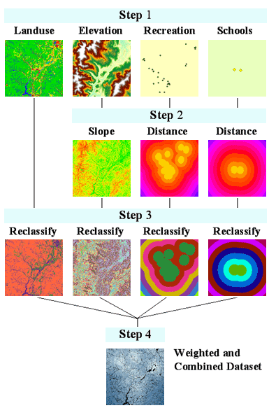
Each of the above examples is considered a suitability model. There are usually four steps in producing a suitability map:
- Input datasets.
Decide which datasets you need as inputs.
- Derive datasets.
When applicable, create the datasets that you can derive from your base input datasets— for example, slope and aspect can be derived from the elevation raster. Create data from existing data to gain new information.
- Reclassify or rescale datasets
Reclassify each dataset to a common scale (for example, 1 to 10), giving higher values to more suitable attributes.
- Weight and combine datasets.
Weight datasets that should have more influence in the suitability model if necessary, then combine them to find the suitable locations.
Below is a flow diagram of a sample for finding the best locations for a school. The input base layers are land use, elevation, recreation sites, and existing schools. The derived datasets are slope, distance to recreation sites, and distance to existing schools. Each raster is then reclassified on a scale of 1 to 10. The reclassified rasters are added together with distance from recreation sites and other schools having a higher weight.

Setting specific values to NoData or setting NoData cells to a value
Sometimes you want to remove specific values from your analysis. This might be, for example, because a certain land-use type has restrictions, such as wetland restrictions, which means you cannot build there. In such cases, you might want to change these values to NoData to remove them from further analysis.
In other cases, you may want to change a value of NoData to a value, such as when new information means a value of NoData has become a known value.