| Label | Explanation | Data Type |
Input Polygon Feature or Raster Zones
| The dataset representing the zones of the first regionalization. The zones can be defined using polygon features or a raster. | Feature Layer; Raster Layer; Image Service |
Categorical Zone Field
| The field representing the zone category of the input zones. Each unique value of this field defines an individual zone. For features, the field must be integer or text. For rasters, the VALUE field is also supported. | Field |
Overlay Polygon Feature or Raster Zones
| The dataset representing the zones of the second regionalization. The zones can be polygon features or a raster. | Feature Layer; Raster Layer; Image Service |
Categorical Overlay Zone Field
| The field representing the zone category of the overlay zones. Each unique value of this field defines an individual zone. For features, the field must be integer or text. For rasters, the VALUE field is also supported. | Field |
Output Features
(Optional) | The output polygon features containing spatial association measures at all intersections of the input and overlay zones. The output features can be used to measure the association between specific combinations of input and overlay zones, such as the association between areas of corn production (crop type) and areas of well-drained soil (soil drainage class). This parameter is only enabled if the input and overlay zones are both polygon features. | Feature Class |
Output Raster
(Optional) | The output raster containing spatial association measures between the input and overlay zones. The output raster will have three fields to indicate the spatial association measures for intersections of the input and overlay zones, correspondence of overlay zones within input zones, and correspondence of input zones within overlay zones. This parameter is only enabled if at least one of the input and overlay zones is a raster. | Raster Dataset |
Correspondence of Overlay Zones within Input Zones
(Optional) | The output polygon features containing the correspondence measures of the overlay zones within the input zones. This output will have the same geometry as the input zones and can be used to identify which input zones closely correspond overall to the overlay zones. Specific zone combinations can then be investigated with the output features. This parameter is only enabled if the input and overlay zones are both polygon features. | Feature Class |
Correspondence of Input Zones within Overlay Zones
(Optional) | The output polygon features containing the correspondence measures of the input zones within the overlay zones. This output will have the same geometry as the overlay zones and can be used to identify which overlay zones closely correspond overall to the input zones. Specific zone combinations can then be investigated with the output features. This parameter is only enabled if the input and overlay zones are both polygon features. | Feature Class |
Derived Output
| Label | Explanation | Data Type |
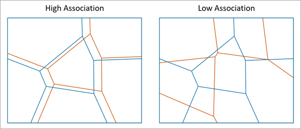
| Global Measure of Spatial Association | The measure of global association between the input and overlay zones. The value ranges from 0 (no association) to 1 (perfect association). | Double |
| Global Correspondence of Overlay Zones within Input Zones | The measure of global correspondence of the overlay zones within the input zones. The value cannot be negative, and values closer to zero indicate higher correspondence (less variability). | Double |
| Global Correspondence of Input Zones within Overlay Zones | The measure of global correspondence of the input zones within the overlay zones. The value cannot be negative, and values closer to zero indicate higher correspondence (less variability). | Double |
