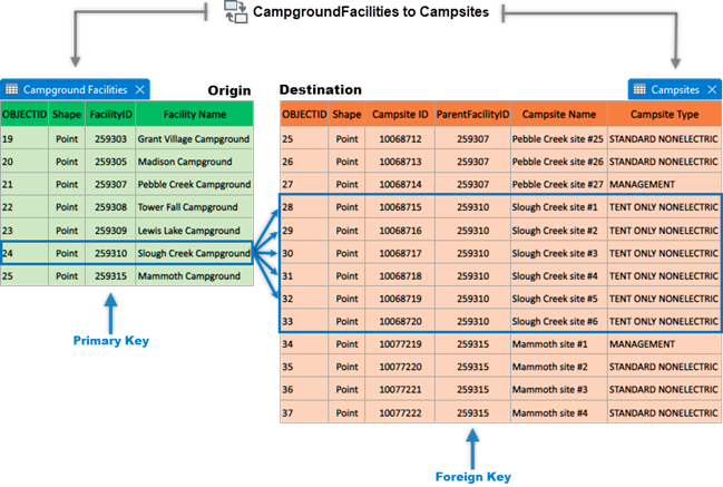
Relationship classes in the geodatabase manage the associations between objects in one class (feature class or table) and objects in another. Objects at either end of the relationship can be features with geometry or records in a table.
For example, a feature class of Campground Facilities (origin table) can be associated with a feature class of Campsites (destination table), because they each share a common field containing common values, FacilityID on the origin table and ParentFacilityID on the destination table and they have the same long integer data type for that field. In this example, associating these records would make it possible to select a single campground facility and access multiple campsites associated with that campground.

Benefits of relationship classes
A relationship class in a geodatabase establishes a connection between two tables based on a common field, also known as a key. This connection can be used to enforce referential integrity or to navigate between related records. The following are some of the benefits and advanced capabilities that a relationship class provides:
- Referential integrity—A relationship class can enforce referential integrity, which ensures that the relationships between tables remain consistent. This means that if a record in the origin table is deleted, all related records in the destination table will also be deleted.
- Improved data entry and editing—When editing data, relationship classes can help ensure that changes are propagated correctly through related tables. This can help prevent data inconsistencies and errors.
- Richer data analysis—When a relationship class has been established between datasets, you can perform more complex queries and analyses. For example, you can find all features in one table that are related to a particular feature in another table.
- Efficient data management—Relationship classes allow for efficient management of related data. Instead of duplicating data in multiple tables, you can store it in one place and create relationships to it from other table.
- Cardinality—Cardinality describes how items or data relate to each other. For example, in a city's GIS data, one-to-one could be one building to one owner. One-to-many could be one bus route serving many bus stops. Many-to-many could be many shoppers visiting many stores. Relationship classes help us understand these connections and make sense of complex data.
- Relationship rules—You can define constraints in the relationship class to ensure that the accuracy and consistency of spatial data is maintained when editing data. For example, a relationship rule could state that each building must be associated with a specific parcel. You can set rules for how things are connected, like one building to one parcel, one bus route to many bus stops, or many shoppers visiting many stores to help maintain data integrity by keeping your data accurate and reliable in your geodatabase. This can help to maintain the integrity of your data.
- Attributed relationships—Relationship classes can store additional information about the relationship itself. For instance, in a relationship between roads and traffic accidents, an attribute could store the number of accidents occurring on each road segment. Relationship classes can have attributes, which allows you to store information about the relationship itself. For example, you could store the date that a relationship was established.
- Notification—Notifications allow for automatic updates. If a change is made in one table, related records in the other table can be automatically updated. Relationship classes can send messages when certain events occur, such as when a relationship is created or deleted. This can be used to trigger custom behavior in your application.
- Navigation—You can navigate relationships in both directions. For example, if you have a relationship between a Customers table and an Orders table, you can find all orders for a particular customer or find the customer associated with a particular order.
- Cascading updates and deletes—Relationship classes support cascading updates and deletes. This means that if a record in the origin table is updated or deleted, the changes can be propagated to related records in the destination table.
Limitations of relationship classes
Relationship classes in the geodatabase manage associations between objects in two related feature classes or tables. However, the following are the restrictions and limitations;
- Relationship classes can only be defined between feature classes or tables in the same geodatabase.
- The feature classes or tables must also be stored within the same geodatabase.
Datasets that participate in more than one relationship class
A feature class or table can participate in more than one relationship class; however, there are some restrictions.
- A given feature class or table cannot be the destination in two composite relationship classes. However, you can have more than one simple relationship between a pair of classes. You may do this if you need to enforce different cardinality, depending on the direction in which you navigate the relationship.
- If a composite relationship class exists between two classes, no other relationship class can be created between the same two classes.
- To create a relationship class in a feature dataset, either the origin or destination class must be in the feature dataset.
- You can have more than one simple relationship between a pair of classes. You may do this if you need to enforce different cardinality, depending on the direction in which you navigate the relationship.
Unsupported relationship classes
The following types and properties of relationship classes are not supported in ArcGIS:
- Recursive relationships in which a relationship exists between records in the same feature class or table are not yet supported in ArcGIS.
- The primary and foreign keys can each be based on one field only; complex primary and foreign keys are not supported in ArcGIS.
If you have determined that using a relationship class in the geodatabase is the most appropriate method for you to use based on the data you have and the questions you're trying to answer, the next steps are to understand geodatabase relationship class types and create a relationship class.