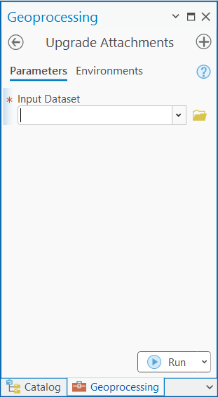
A geodatabase dataset enabled for attachments must be upgraded to associate an existing geodatabase feature class or table with an ArcGIS Survey123 form. The Upgrade Attachments geoprocessing tool adds two editable fields to the existing ATTACH table: KEYWORDS and EXIFINFO. These fields are used by apps, such as Survey123, to store additional information about the attachments.
Note:
This geoprocessing tool only supports geodatabase feature classes and tables enabled for attachments.
Caution:
If the attachments are upgraded, the minimum client version of the attachment table is set to ArcGIS Pro 2.6. This means that the following limitations apply when working with the data in ArcGIS Desktop or earlier versions of ArcGIS Pro:
- The attachment table cannot be opened.
- You can add features or records to the dataset with attachments enabled, but you cannot delete features or records.
- If ArcGIS Desktop was used to create a replica of this data, attachments are not a part of the replica.
To upgrade attachments using the Upgrade Attachments tool, complete the following steps:
-
On the Analysis tab in the Geoprocessing group, click Tools, and search for or browse to the Upgrade Attachments tool in the Data Management Tools toolset.

- Click the Upgrade Attachments result to open the tool.
The Upgrade Attachments tool dialog box appears with a parameter to enter an input dataset.

- For Input Dataset, use the browse button
 to select a feature class or table, or click the down arrow to choose a dataset from the active map.
 - Click Run to upgrade the dataset.
New fields are added to the ATTACH table after the tool has completed successfully in ArcGIS Pro. However, once the dataset has been shared as a web layer (feature service), the attachment table and new fields are not accessible. The fields are still present for apps such as Survey123 to use the existing feature layer in a new form with ArcGIS Survey123 Connect.
Learn more about how the new fields are used with an existing feature layer in Survey123