Available with Spatial Analyst license.
Available with Image Analyst license.
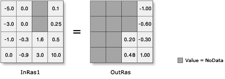
The Logarithmic math tools can process both integer and floating-point input values. However, note that input values that are 0 or negative will be NoData in the output raster.
The following illustrations demonstrate the output values from both positive and negative floating-point inputs, as well as inputs of value 0.
Logarithmic tools on float input
| Tool | Illustration and Python syntax |
|---|---|
| Ln |  |
| Log10 |  |
| Log2 |  |