Available with Business Analyst license.
Suitability Analysis is used to rank and score sites based on multiple weighted criteria. Suitability can be ranked based on data variables from the installed Business Analyst dataset or ArcGIS Online with your site attributes. Once you select your criteria, you can assign weights to them, get weighted scores for each potential site, and review final site score ranks from most to least suitable. Suitability Analysis can be run on a set of point location sites, polygon areas, standard geographies, or any combination thereof. The Suitability Analysis toolset is accessed via the Business Analyst toolbox in the Geoprocessing pane.
In addition to a complete set of geoprocessing tools, a Suitability Analysis tab is exposed on the ribbon when a Suitability Analysis layer is created. To access the tab, select your Suitability Analysis layer in the Contents pane and click Suitability Analysis.
From the Suitability Analysis tab, you can access the following workflow components:
- Add Criteria—Allows you to call the geoprocessing tool to add any of the three types of criteria: variable, point, and field
- Suitability Criteria—Used to review and change criteria settings
- Attribute Table—Opens the Suitability Analysis Layer attribute table, which contains all added criteria individually and collectively scored for each record
- Reset Weights—Redistributes weighting evenly across all criteria to achieve equal importance
- Auto Calculate—Automatically recalculates suitability scores any time changes are made to criteria
Step-by-step guide
The following guide leads you through an example of how to run Suitability Analysis. The workflow consists of identifying candidate locations, adding criteria, setting parameters, and calculating a suitability score.
The example scenario is as follows: you are an analyst at a major commercial real estate company. You have been tasked with finding the most suitable market to site a new fulfillment facility on behalf of your e-commerce client. Once the ideal market is identified, you use Suitability Analysis to pinpoint the best site within it. However, for this tutorial, your goal is only to identify the best market for expansion. The following criteria will be used to determine the optimal market:
- High population count
- High percentage of adults with college degrees
- High rate of ethnic diversity
- Median household income that is in line with other successful markets
- Relatively affordable housing
- Presence of an international airport within 50 miles of the market center
- Presence of preferred supply chain or shipping providers (hubs)
Additionally, your client recently completed analysis of their best employees using Esri Tapestry Segmentation and provided counts of the corresponding LifeMode category. They provided counts of LifeMode 5 for each county in the United States, and you have appended this attribute to your input layer.
Your client identifies individual United States counties as markets, and these will be used as your input layer.
To begin the Suitability Analysis workflow, use the USA_ESRI_2023 dataset.
Create a Suitability Analysis layer
With ArcGIS Pro open and your data in place, the first step is to create a Suitability Analysis layer.
- Open the Make Suitability Analysis Layer tool.
- From Input Features, you have the option to select a feature layer from your project or browse for hosted or shared content. Click the browse button
 and choose US_Counties.
 - Type Market Suitability Candidates in the Layer Name text box.
- Click Run.
Your Suitability Analysis layer is created and added to the Contents pane.
Next, you will access ArcGIS Living Atlas of the World to enrich candidate sites with demographic criteria identified by your client as critical.
This action is completed using the Add Variable Based Suitability Criteria geoprocessing tool.
Select your criteria
To select criteria, complete the following steps:
- Open the Add Variable Based Suitability Criteria geoprocessing tool.
- Identify your Suitability Analysis layer as the input and click the Add variable button
 .
. The Data Browser dialog box appears.
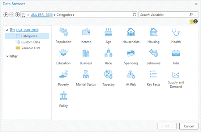
- Under the USA_ESRI_2023 dataset, click Categories.
The pane on the right displays the dataset's categories.
- Select your variables by either clicking the respective categories or using the Search Variables field in the upper right.
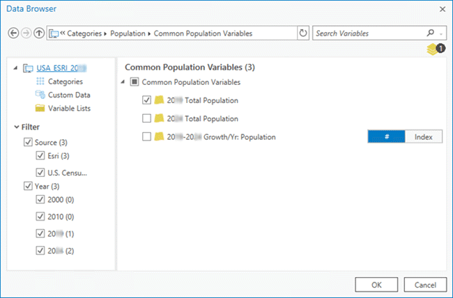
- Select the following variables:
- 2023 Total Population—To identify markets with high total population counts.
- 2023 Diversity Index—To measure the likelihood that two people selected at random are of a different ethnicity or race. Higher values equal greater diversity within the market.
- 2023 Educational: Bachelor's Degree—Percentage of population to have earned a bachelor's degree.
- 2023 Median Home Value—Index measures the home value versus the United States national median, which has an index of 100.
- 2023 Median Household Income
After each variable has been chosen, an updated count appears below the Search Variables field.

- When you are finished adding variables, click OK.
The results are displayed in the Geoprocessing pane.
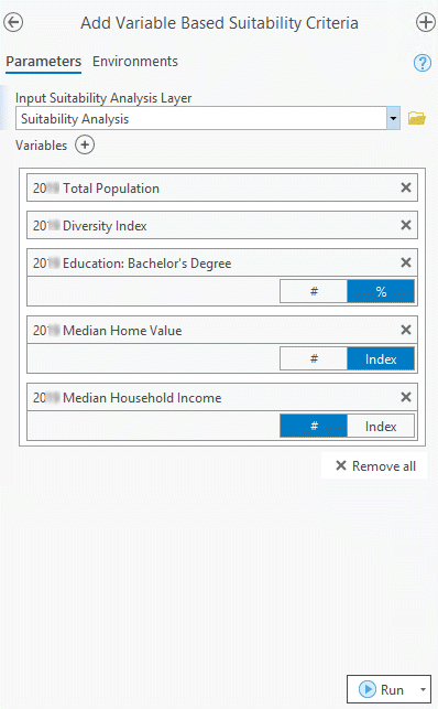
From here, you are able to add or remove variables, reorder variables, or switch between values: Index
 , Number
  , or Percentage
  .
. - Click Run.
Now that you have created criteria, you will review the default settings for each.
Review and edit your criteria
In this section, you will perform steps using the Suitability Analysis tab.
- In the Contents pane, select the Market Suitability Candidates layer.

The Suitability Analysis tab appears on the ribbon.
- Click the Suitability Analysis tab and click Suitability Criteria in the Criteria group.
The Site Suitability pane appears. By default, all five criteria are equally weighted, and the Influence settings are positive.
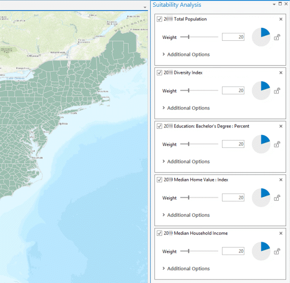
Since your client has specified needing proximity to large international airports and supply chain hubs within the market, you decide that changes are to be made but wait until point- and field-based criteria are added.
Add point-based criteria
In this part of the tutorial, you will create point-based criteria using two methods:
- Count type—For identifying markets that contain supply chain hubs
- Distance type—For identifying markets within ideal proximity to large airports
Data from ArcGIS Online will be used for your supply chain hubs and large airports analysis.
- Open the Add Point Layer Based Suitability Criteria tool.
- In the Add Point Layer Based Suitability Criteria pane, do the following:
- For Input Suitability Analysis Layer, choose Market Suitability Candidates.
- For Site Layer ID Field, choose OBJECTID.
The Site Layer ID Field parameter uniquely identifies each polygon and corresponding attribute table record.
- Next to the Point Features parameter, click the browse button
 to browse to the Supply_Chain_Hubs point feature.
 - Click the Criteria Type drop-down arrow and choose Count.
- Click Run.
The parameters for large international airports are to be scored based on proximity to the market center. Therefore, you select Minimal Distance for the Criteria Type parameter. Minimal Distance returns the minimum distance from the closest point to the center of each polygon.
- If the Add Point Layer Based Suitability Criteria geoprocessing tool is still open, close and reopen it to refresh.
- Set the parameter settings as follows:
- For Input Suitability Analysis Layer, choose Market Suitability Candidates.
- For Site Layer ID Field, choose OBJECTID.
- Next to the Point Features parameter, click the browse button
 to browse to the Large_Intl_Airports point feature class.
 - Click the Criteria Type drop-down arrow and choose Minimal Distance.
Selecting Minimal Distance requires information on distance type and units. Therefore, additional parameters requiring input are returned in the tool.
- For Distance Type, choose Driving Distance.
- For Measure Units, choose Miles.
- Click Run.
Note:
The optional Site Centers Features parameter can be used to identify an alternative to Suitability Layer polygon centroids and is used in the distance calculation.
With variable and point-based criteria appended to your Suitability Analysis layer, you are now ready to add field-based criteria.
Add field-based criteria
Your client knows the characteristics of their best employees and would like to site in an area with a large pool of potential applicants who are a good fit. They have identified a correlation between Tapestry LifeMode Group 5 households and robust bases of successful employees. A count of LifeMode Group 5 households has been appended to the Suitability Analysis layer but is yet to be set up as analysis criteria.
- From the Suitability Analysis toolset, open the Add Field Based Criteria geoprocessing tool.
- For Input Suitability Analysis Layer, choose your suitability layer and the attribute to be added as criteria.
- Click Run.
With all criteria in place, you are ready to refine to your client's specifications.
Set criteria properties
Additional information from your client has indicated that markets with a median household income of around $55,000 fit well with their base compensation plan and employee needs.
You know that Suitability Analysis allows the introduction of ideal criteria values, in addition to positive and negative criteria influence, and that this can be set in one of two ways: using the Set Criteria Properties geoprocessing tool or from Additional Options in the Site Suitability pane. You decide to use the Suitability tab to set the ideal value, since you are working directly with the map.
- In the Contents pane, highlight your Suitability Analysis layer.
- On the ribbon, click the Suitability Analysis tab and click Suitability Criteria in the Criteria group.
The Site Suitability pane appears.
- For 2023 Median Household Income, expand Additional Options.
- Set Influence to Ideal.
- Type 55000 as the Ideal value. In this case, $55,000 represents your ideal household income.
Note:
You can exclude outlying values by setting Minimum and Maximum threshold values.
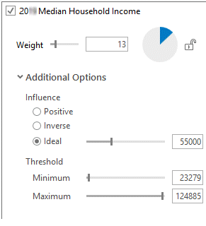
Markets will now be evaluated for this criteria based on how closely their value aligns with your ideal value.
- With the Site Suitability pane still open, make the following changes to the remaining criteria:
- 2023 Total Population—Set Weight to 8.
- 2023 Education: Bachelor's Degree: Percentage—Set Weight to 12.
- 2023 Diversity Index—Set Weight to 20.
- 2023 Median Home Value: Index—Set Weight to 10 and set Influence to Inverse.
Setting Influence to Inverse will show preference to lower median home values.
- Confirm that 2023 Median Household Income has weight set to 10 and Influence set to Ideal.
- Point Count—Set Weight to 15.
- Distance—Set Weight to 10.
- 2023 HHs: LifeMode Group 5—Set Weight to 15.
The highest-weighted criteria is 2023 Diversity Index—2023 Median Household Income is set to Ideal with a value of 55000, and 2023 Median Home Value: Index has Influence set to Inverse, meaning lower values are preferred.
Calculate a suitability score
With your criteria settings and values set, you can now calculate a suitability score.
- From the ribbon, click the Suitability Analysis tab and click Calculate
 in the Suitability Score group.
Your results are returned in three places: the map; the Contents pane, which defines ranges of corresponding map shading; and the Market Suitability Candidates layer attribute table.
You have now completed a first round of Suitability Analysis, using all three types of criteria, with the Suitability Analysis geoprocessing toolset and the Suitability Analysis tab.