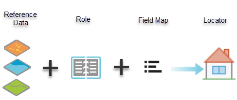
One of the first processes in geocoding with your own data is creating a locator. Creating a locator involves selecting reference data—such as street centerlines, tax parcels, or building name layers—determining the correct locator role for the reference data, and mapping the appropriate data fields to the fields from the selected locator role or roles. You can create a single locator using multiple reference datasets and roles, which can be used to search for multiple types of locations at once.

Locator components
The key components for building a locator are described in the sections below.
Primary reference data
The quality of your geocoding results is based on the quality of your primary reference data, which needs to include the geometry and attributes for the addresses and places you want to locate. For example, when searching for house number addresses, the reference data must contain the house number ranges, street names, or address attributes of the specific streets in separate fields. Reference data can consist of the following spatial features:
- Addresses—Points, streets, parcels, building footprints
- Points of interest—Landmarks, place-names, buildings
- Populated places—Cities, regions, countries, postal codes
- Locations—Wells, parking meters, census tracts
Locator role
The locator role defines the type of data that is being used (parcel, street centerline, postal, point of interest, and so on) and provides the appropriate fields to use when building the locator and the information returned in the geocoding results. The primary locator roles provided with ArcGIS Pro allow you to build the following types of locators as either a single role locator or a multirole locator:
- Point Address—A street address based on points that represent house and building locations. This includes a subaddress, which is based on points that represent house and building subunit locations, such as suite, floor, and apartment.
- Parcel—A plot of land that is considered real property and may include one or more homes or other structures. A parcel typically has an address and a parcel identification number assigned to it, for example, 17 011100120063.
- Street Address—A street address based on streets where the house number is interpolated from a range of numbers. This includes intersections, street name, street blocks, and street extension.
- Point of Interest—Consists of administrative divisions, place-names, businesses, landmarks, and geographic features, for example, Starbucks.
- Postal—Postal codes and postal codes with extensions, where polygon reference data should be used to return optimal reverse geocoding results.
- Localities—Administrative zones or areas such as cities, neighborhoods, counties, provinces, districts, territories, and states where polygon reference data should be used to return optimal reverse geocoding results.
Field map
Choose fields in the primary reference data that align with the locator role or roles you chose. Not selecting the appropriate fields when building the locator affects how an address is matched when geocoding or searching for addresses and places.
Alternate name tables
The reference data described above is the primary reference data that is required to store at least one set of address attributes for each feature. However, a feature can be referred to by many names. For example, the official name for a street is 27th Street, but people may refer to it as Old County Road 30. In cases where features have multiple names, each alternate name can be stored in another reference table. The records in the table are joined to the primary reference data using a field value stored in an ID field that corresponds to both the primary reference data and alternate name table. Alternate name table roles provide the appropriate fields that must be used when building the locator to support alternate names. Using alternate name tables is optional when creating a locator.
Learn more about alternate name tables and alternate name table roles.
Related topics
- Create a locator
- Combine multiple locators into a composite locator
- Combine multiple data layers into a single locator
- Keep your locator up to date
- Introduction to sharing locators
- Fundamentals of alternate name tables
- Address elements
- Tips for fixing errors in reference data
- Primary locator roles
- Alternate name table roles