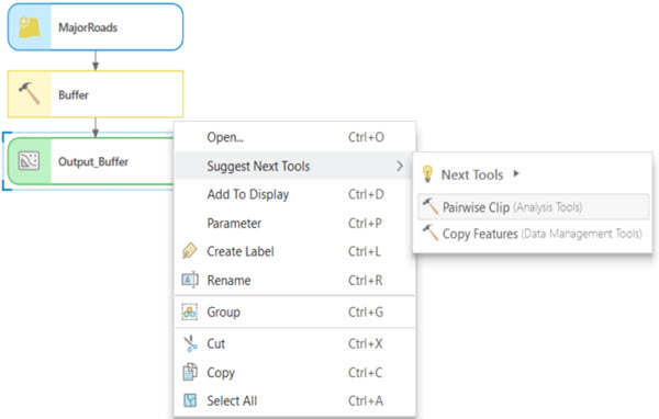
Tool suggestions in ModelBuilder are based on semantic search and provide more robust results than a traditional keyword-based search. Tools are suggested in ModelBuilder based on tools that already exist in a model and it helps in building a model workflow.
Learn more about semantic search in ArcGIS Pro
Use search in ModelBuilder
Access the search in ModelBuilder by typing ai: followed by the query text, using any of the following:
- On the ModelBuilder tab, click the Tools drop-down arrow
 .
. - On the ModelBuilder toolbar, click the Tools drop-down arrow
 .
. - Start typing in the Model window to open the Add Tools To Model window.

Use tool suggestions in ModelBuilder
Tool suggestions are provided after adding the first tool to a model to help find the next step in a model workflow.
On the ModelBuilder ribbon, click the Suggest Tool button  to provide suggestions using the existing tools in the model. This causes a prediction tracing back up to five tools in the model workflow.

Alternatively, right-click the output of a tool and click Suggest Next Tools to view suggestions for tools to use for the next step.

In ModelBuilder, tool suggestions include both geoprocessing and model-specific tools such as iterators, utilities, and logical tools.
The suggestions are based on a sequence prediction model for geoprocessing and model tools. The model is trained using tool usage logs from ArcGIS Pro users who participate in the Esri User Experience Improvement program. The model suggests tools that are commonly used after the tools already in the model. If none of the suggestions seem relevant to your requirements, click the Show More Suggestions button  to generate alternative suggestions.
Example: Delineate a watershed using tool suggestions
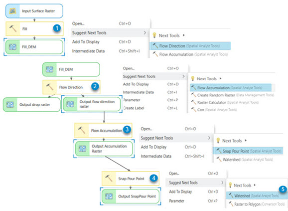
A watershed is an area of land where water flows into a common stream or river. You can delineate a watershed from a digital elevation model (DEM) using a series of tools in the Hydrology toolset. Using the following steps, you will find that after adding the first tool in a model, the tool in the next step will be offered as a suggestion for you to use next.
- Use the Fill tool to remove any sinks in the DEM.
- Use the Flow Direction tool to calculate the direction water flows across land.
- Use the Flow Accumulation tool to calculate the number of cells that drain into another cell.
- Use the Snap Pour Point tool to create a pour point and snap it to the nearest cell with a high flow accumulation value.
- Use the Watershed tool to delineate the watershed.

By following the tool suggestions in the model, you'll find that you can complete this analysis workflow in less time. An example of the output from this model is below.
