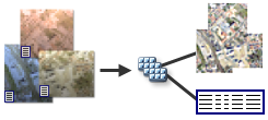
There are two ways to organize, store, and manage raster data (raster data models) in ArcGIS:
- Raster dataset

- Mosaic dataset

Raster dataset
Most imagery and raster data (such as satellite images or DEMs) are provided as a raster dataset. The term raster dataset refers to any raster data model that is stored on disk or in a geodatabase. It's the basic raster data storage model on which others are built, such as mosaic datasets. It's also the output from many geoprocessing tools that process raster data.
A raster dataset is any valid raster format organized into one or more bands. Each band consists of an array of pixels (cells), and each pixel has a value. A raster dataset has at least one band. More than one raster dataset can be spatially appended (mosaicked) together into a larger, single, continuous raster dataset.
Raster datasets can be stored in many formats, including TIFF, JPEG 2000, Cloud Raster Format (CRF), and NITF.
Raster datasets are represented with the raster dataset icon  .
.
The table below lists the important qualities of a raster dataset.
Raster dataset overview
| Qualities | Example |
|---|---|
|
|
Learn more about raster datasets
Note:
Raster products make adding imagery from specific sensors or data providers to a map simpler because each raster product has a unique set of enhancements and band combinations to provide an optimal view of the data. The information in the metadata files is used to generate the raster products, such as Landsat, Sentinel, or WorldView satellite imagery.
Mosaic dataset
A mosaic dataset is an assortment of image or raster datasets stored as a collection and viewed or accessed as a single mosaicked image or individual images as items comprising the mosaic dataset. These collections can be very large, both in total file size and number of image datasets. The image data is added according to its raster type—which identifies metadata, such as georeferencing, acquisition date, and sensor type, along with a raster format. The image data in a mosaic dataset can remain in its native format on disk or, if required, be loaded into the geodatabase. The metadata can be managed in the raster record as well as attributes in the attribute table. Storing metadata as attributes enables parameters such as sensor orientation data to be managed and allows fast queries to enable selections.

The image data in a mosaic dataset does not have to be adjoining or overlapping but can exist as unconnected, discontinuous datasets. For example, you can have images that completely cover an area, or you can have many strips of images that may not join to form a continuous image (such as along pipelines).
The data can also be completely or partially overlapping, and can be captured over different dates. The mosaic dataset is well suited for storing temporal data. You can query the mosaic dataset for the images you need based on time or date and use a mosaic method to display and process the mosaicked image according to a time or date attribute.
Mosaic datasets are represented with the mosaic dataset icon  .
.
The table below lists the qualities of a mosaic dataset.
Mosaic dataset overview
| Feature | Example |
|---|---|
|
|

