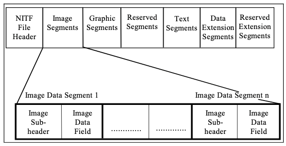
The National Imagery Transmission Format (NITF) was created to help simplify the transfer of image products used by the United States Department of Defense (DoD) and the Intelligence Community (IC). To meet this requirement, the NITF was designed to allow you to store a variety of data types with image support data (ISD) in a single file.
The following are the fundamental objectives of NITF:
- Provide a means for diverse systems to share imagery and associated data.
- Enable systems to exchange comprehensive information in a single file to address diverse needs and capabilities.
- Allow you to select only data items that correspond with your needs and capabilities.
- Minimize the cost and schedule required to achieve the capability to share imagery and associated data.
To meet these objectives, a committee of experts within the NITFS Technical Board (NTB) focus group of the Geospatial-Intelligence (GEOINT) Standards Working Group (GWG), facilitates the development, selection, adoption, profiling, documentation, application, implementation, and testing of standards essential to establishing interoperability and quality, resulting in the NITF standards.
NITF, and associated standards, have evolved to keep pace with the wide variety of capabilities available with modern systems. As a result, data producers may only implement what they need from the NITF standard. To provide guidance on implementation, several implementation specifications have been created and are also maintained by the NTB to further support interoperability between data producers and consumers. Some common examples of NITF implementation specification are the NITF Commercial Dataset Requirements Document (NCDRD), the Motion Imagery for NITF (MIE4NITF), and the Sensor Independent Complex Data (SICD) specifications.
Note:
Data supplied as part of humanitarian efforts that are supported by the DoD and IC is often delivered as NITF files.
Data structure
NITF is structured with a basic file header and a variety of data type segments. Data and properties are further described using Data Extension Segments (DES) with Tagged Record Extensions (TRE).

Learn more about NITF
The primary reference document for the NITF 2.1 file format standard is MIL-STD-2500C. It is recommended that you become familiar with the MIL-STD-2500C document and the appropriate implementation specifications when you use a National Geospatial-Intelligence Agency (NGA) or DoD imagery product that is delivered as an NITF file.
For United States partners, especially countries included in the North Atlantic Treaty Organization (NATO), the NATO Secondary Imagery Format (NSIF) is also based on the NITF standard. While NSIF and MIL-STD-2500C standards are similar, it is important to note that NATO countries have their own implementation standards when building imagery products.
For information regarding NITF standards documents, send an email to NCDRD-NCDDD-Custodian@nga.mil.