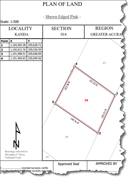
You can create a parcel layout or a title map layout for a single parcel in the parcel fabric using the Export Sequenced Parcel Features geoprocessing tool. The tool exports the features of a selected parcel to individual feature classes that can be used for the creation of parcel layouts. Additional fields are added to the exported feature classes such that parcel features can be labeled and tabulated in a clockwise sequence.
Any related tables of the parcel features will be exported with the individual feature classes. Examples of related tables could be feature-linked annotation or attachments.
Parcel layouts
A parcel layout or title map layout is a depiction of a single parcel that is described according to local regulations. A parcel layout or title map can display the following:
- A graphic of a single parcel with sequentially labeled lines or corner points
- Owner names
- Registration details
- A parcel identification number
- A table listing x,y coordinates for each sequentially labeled point
- A table listing dimensions for each sequentially labeled line
- A table listing curve parameters for each sequentially labeled curve
- Connection lines or ties from the parcel
- Related information about the parcel record
- Related information about the parcel, such as feature-linked annotation

When creating a parcel layout, consider the following:
- After the parcel layout has been created, you can use the Export Sequenced Parcel Features tool to export and overwrite the parcel features used in the layout. The layout can be updated with a different parcel in a different location.
- If you want to add two tables to the layout for a single parcel feature, you will need two layers, one for each table. For example, if you want to add a table for curves and a table for straight lines, you will need to add two parcel line feature layers, each with definition queries that query for straight lines and curves.
- You can export the layout to a PDF.
- You can further automate the layout creation and export process using ArcGIS Pro SDK orPython scripting.