Much like a spatial reference, a map can have a temporal reference. This is done by defining a time zone for a map. The map's time zone is used for two purposes: to fully describe the time values shown on the time slider when filtering content and to optionally adjust the display of all date-time values into a single shared time zone. The time zone of the map works in conjunction with the time zone property of individual layers in the map.
When maps contain layers in different time zones, setting the map time zone is crucial to ensure data aligns properly through time. For example, to accurately filter and compare a layer showing power outages in (GMT-5) New York time (Eastern Time zone, commonly referred to as EST) and a layer showing lightning strikes in (GMT+0) Coordinated Universal Time zone (commonly referred to as UTC), the data values must be offset to a common reference point. The time zone of the map provides this reference point. That is, a power outage that began at 4:03 p.m. EST could only be caused by a lightning strike at 9:03 p.m. UTC.
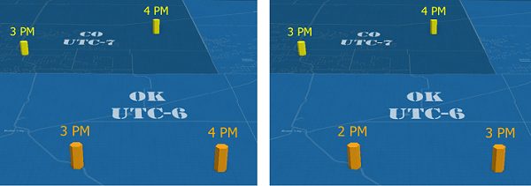
The following images demonstrate this map time value adjustment using two layers in neighboring time zones:

When a map time zone results in a temporal adjustment such as this, the display of temporal values is adjusted in all areas of the software, including the attribute table, the Attributes pane, pop-ups, layouts, and reports.
If you work entirely within a single time zone, defining the time zone property for maps and layers is not required because there are no time value conversions needed to filter or display. However, it is still recommended that you set a map time zone, especially if you intend to publish the content as a service or share the content with others in a different time zone.
Set map time properties
To apply a time zone to all temporal values in a map or scene, complete the following steps:
- Right-click the map name in the Contents pane, and click Properties to open the Map Properties dialog box.
- On the Time tab, choose a time zone from the Time Zone drop-down menu as follows:
- <Device time zone>—The dynamic system time zone value of the machine when ArcGIS Pro was opened. Use this option to have the time zone dynamically shift to match a machine that periodically changes its time zone.
- <Computer time zone>—The current time zone of the machine. Use this option to select the current time zone of the machine. Once chosen, the time zone remains constant even if the machine time zone is altered.
Optionally, choose the format to use when time zones are displayed as follows:
- IANA—Time zones are displayed using Internet Assigned Numbers Authority (IANA) extended names including both standard and daylight offsets.
- IANA (abbreviated)—Time zones are displayed using IANA location names including only the standard offsets.
- Microsoft Windows—Time zones are displayed using the Microsoft Windows operating system names. This is the default.
Note:
If you prefer to set this at the application level instead of once in each map, you can set the default on the Map and Scene tab of the project Options dialog box.
- Optionally, check Adjust for Daylight Saving to view the data in daylight saving time, when applicable, or uncheck it to always show it in standard time.
- Optionally, check Display values in this time zone to adjust the display of all temporal values so that they align with the selected time zone.
- Click OK to apply the changes and close the Map Properties dialog box.
Edit temporal values that are displayed in the map time zone
When the Display values in this time zone map time option is enabled, both the layer and the map time zone values are displayed as a tooltip in the attribute table when you hover over the column header, as well as on any calendar control when editing the value.
You can edit a temporal attribute in either the time zone of a layer or of a map. By default, values are assumed to be in the map time zone and are adjusted to the time zone of the layer when saved.
To temporarily use the time zone of the layer instead, open the calendar control from within the cell of the attribute table or the Attributes pane, and uncheck the Use map time zone option. The time zone reflected in the calendar control updates to display the layer time zone. A temporal value entered while this option is disabled is saved as entered because no display adjustment is being used.