Available with Location Referencing license.
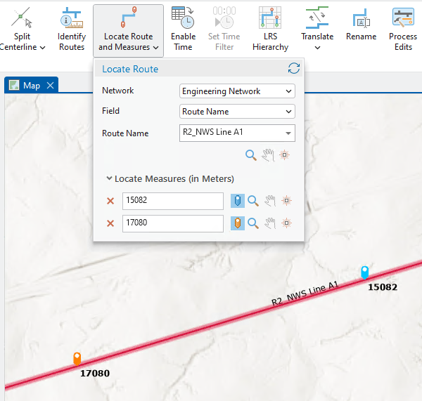
Use the Locate Route and Measures tool to search for a route and locate measures on it. You can find and zoom to a route, place a marker at a specific measure, digitize a centerline by snapping to that measure marker, and use the resulting centerline in a route editing activity.
- Click the Location Referencing tab.
- In the Tools group, click the Locate Route and Measures drop-down arrow.
- Choose the network that contains the route you want to locate in the Network drop-down list.
If there is only one network in the project, it is populated automatically and the drop-down option is unavailable.
- In the Field drop-down list, choose the field you want to use to locate the route.
- Provide the route name or route ID and click Zoom
 .
.The map zooms to the location of the route (highlighted in red), and the Locate Measures options appear.

You can also use the following tools to navigate to the searched route:
Tool Description Zoom

Keeps the map focused on the searched route
Pan

Keeps the zoom level intact
Flash

Flashes the route on the map
- Provide the measure value that you want to locate in the first Locate Measures text box, and click the blue snappable marker button
 .
.A blue snappable marker
 with the measure value appears on the map.
 - Optionally, provide a measure value in the second Locate Measures text box and click the orange snappable marker button
 to locate another measure on the same route.
An orange snappable marker
 with the measure value appears on the map.
Note:
Depending on your configuration, the Select a Route table may appear for routes that are time sliced.

If the LRS layers are time enabled, you can set the map to a previous date using the time slider. The measure marker is added on the route according to the time set in the time slider.
If the LRS layers are not time enabled, the Select a Route table appears, displaying all time slices of the selected route. Select a time slice for which you want to locate a measure and add a marker.
- Once markers are placed at the specified measures along the route, you can do the following:
- Digitize a centerline by snapping to measure markers.
- Click Reset
 to clear all previously located routes and measures on the map.