Aspect describes the directional orientation of slope on a surface. Aspect is calculated for each cell in a raster surface and each triangle in a triangulated irregular network (TIN)-based surface such as the TIN, terrain, and LAS dataset.
The LAS dataset, terrain, and TIN layers can be symbolized using aspect values. Learn more about the symbology options for TIN, terrain, and LAS dataset layers.
Aspect measurement
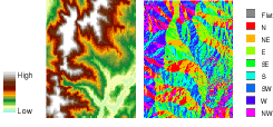
Aspect is measured in degrees that increment in a clockwise direction from 0 degrees (due north) to 360 degrees (again due north, coming full circle). Flat slopes have no direction and are assigned a value of -1. The aspect measurements are typically classified into directional

The following image shows an input elevation grid and the output aspect grid:

Applications
The following are example applications for the aspect function:
- Find all north-facing slopes on a mountain as part of a search for the best slopes for ski runs.
- Calculate the solar illumination for each location in a region as part of a study to determine the diversity of life at each site.
- Find all southerly slopes in a mountainous region to identify locations where the snow is likely to melt first as part of a study to identify those residential locations that are likely to be first affected by runoff.
- Identify areas of flat land to find an area for a plane to land in case of an emergency.