| Label | Explanation | Data Type |
Input Raster | The input raster dataset. | Mosaic Layer; Raster Layer |
Output Raster Dataset | The output raster dataset. When storing the raster dataset in a file format, specify the file extension as follows:
When storing a raster dataset in a geodatabase, do not add a file extension to the name of the raster dataset. When storing a raster dataset to a JPEG format file, a JPEG 2000 format file, a TIFF format file, or a geodatabase, you can specify Compression Type and Compression Quality values in the geoprocessing environments. | Raster Dataset |
Summary
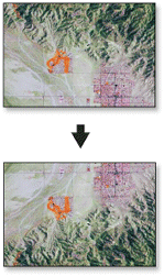
Reorients the raster by turning it over, from top to bottom, along the horizontal axis through the center of the raster. This may be useful to correct raster datasets that are upside down.
Illustration

Usage
This tool flips the grid from top to bottom along the horizontal axis through the center of the region.
You can save the output to BIL, BIP, BMP, BSQ, DAT, Esri Grid, GIF, IMG, JPEG, JPEG 2000, PNG, TIFF, MRF, or CRF format, or any geodatabase raster dataset.
When storing a raster dataset to a JPEG format file, a JPEG 2000 format file, or a geodatabase, you can specify a Compression Type value and a Compression Quality value in the geoprocessing environments.
This tool supports multidimensional raster data. To run the tool on each slice in the multidimensional raster and generate a multidimensional raster output, be sure to save the output to CRF.
Supported input multidimensional dataset types include multidimensional raster layer, mosaic dataset, image service, and CRF.
Parameters
arcpy.management.Flip(in_raster, out_raster)
| Name | Explanation | Data Type |
in_raster | The input raster dataset. | Mosaic Layer; Raster Layer |
out_raster | The output raster dataset. When storing the raster dataset in a file format, specify the file extension as follows:
When storing a raster dataset in a geodatabase, do not add a file extension to the name of the raster dataset. When storing a raster dataset to a JPEG format file, a JPEG 2000 format file, a TIFF format file, or a geodatabase, you can specify Compression Type and Compression Quality values in the geoprocessing environments. | Raster Dataset |
Code sample
This is a Python sample for the Flip tool.
import arcpy
arcpy.Flip_management("c:/data/image.tif", "c:/data/flip.tif")This is a Python script sample for the Flip tool.
##====================================
##Flip
##Usage: Flip_management in_raster out_raster

import arcpy

arcpy.env.workspace = r"C:/Workspace"

##Flip a TIFF format image
arcpy.Flip_management("image.tif", "flip.tif")
Environments
Licensing information
- Basic: Yes
- Standard: Yes
- Advanced: Yes