Disponible avec la licence Location Referencing.
The calibration points used by ArcGIS Pipeline Referencing to calibrate routes are stored in a simple feature class. Calibration points on a route can be edited using the tools provided by the Location Referencing tab. The workflow to edit a calibration point is below.
Modify measure values and temporality
Existing calibration points can have the start date, retire date, and measure updated using the Edit Calibration Point tool  on the Location Referencing tab. This tool also allows downstream recalibration to be applied to a route where a calibration point is edited.
Astuce :
To update the location of a calibration point, first delete the existing calibration point using the Delete Calibration Point tool , then add a new calibration point at the new location using the Add Calibration Point tool.
The following scenario is an example of route calibration with downstream recalibration after modifying a calibration point:
The following scenario is an example of a route calibration point without downstream calibration after modifying a calibration point:
Step A—The route's existing calibration points and route calibration before modifying with checked.
Step B—An existing calibration point is edited with a user-defined measure of 5.
Step C—When the tool is run, the calibration point is edited, downstream calibration points have calibration updated, and the route is recalibrated.
The following is an example of route calibration point without downstream calibration after modifying a calibration point:
Step A—The route's existing calibration points and route calibration.
Step B—An existing calibration point is edited with a user-defined measure of 5.
Step C—When the tool is run, the calibration point is modified and the route is recalibrated. The result of route calibration is no changes to downstream calibration point values.
Complete these steps to edit calibration points on a route:
- Click the Location Referencing tab.
- Click the Edit Point button
 on the Location Referencing tab.
Remarque :
Traditionally versioned networks must be edited through a direct connection to the geodatabase. Branch versioned networks, which includes any network configured with a user-generated route ID, must be edited through a feature service.
- Select an existing calibration point on the map.
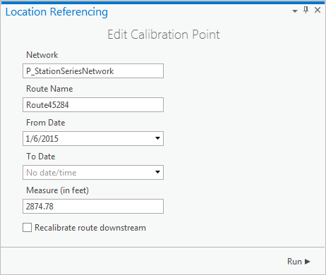
The Edit Calibration Point pane appears with attributes for the selected calibration point populated.

The Network text box is populated with the network selected on the map. The Route Name text box is populated with the route name of the calibration point selected on the map. The From Date and To Date text boxes are populated with the from and to dates of the calibration point. The Measure text box is populated with the measure of the selected calibration point.
- You can change the From Date and To Date to set when this calibration is applied to the route.
- You can change the Measure value of this calibration point.
- Choose whether you want to recalibrate the route downstream by checking or unchecking the check box.
- Checked—Applies recalibration to downstream calibration points along the route. For example, existing calibration at the location where the calibration point is being added is 5, and the next downstream calibration point at the end of the route has a measure of 10. If the measure was changed to 6 and is checked, the downstream calibration point would have 1 added to the measure and change to 11.
- Unchecked—Results in no recalibration for the next downstream calibration point along the route. Using the example above, changing the measure from 5 to 6 but not checking the check box would result in the downstream calibration point maintaining a measure of 10.
- Click Run.
Remarque :
Calibration on the route is updated. - If more calibration points are ready to be edited, repeat the steps above to edit them.
Remarque :
If a message about acquiring locks or reconciling appears, conflict prevention is enabled.
Vous avez un commentaire à formuler concernant cette rubrique ?