Résumé
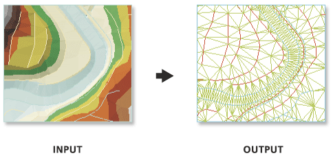
Crée des entités linéaires 3D à l'aide des segments de triangle d'un jeu de données TIN (Triangulated Irregular Network, réseau triangulé irrégulier).
Illustration

Utilisation
Utilisez le paramètre Type de segment pour extraire un type spécifique de segment de triangle.
L'entité en sortie contient un champ nommé EdgeType qui utilise des valeurs d'entier afin de représenter le type de segment représenté par chaque ligne :
- 0 – Segment régulier, ou segment qui n'a pas été spécifiquement défini en tant que segment rigide ou malléable. Ce type de segment est produit par la triangulation des points de données TIN.
- 1 – Segment malléable, ou segment qui représente une transition progressive dans les valeurs de pente.
- 2 – Segment rigide, ou segment qui représente une transition plus abrupte dans les valeurs de pente.
Syntaxe
arcpy.3d.TinEdge(in_tin, out_feature_class, {edge_type})| Paramètre | Explication | Type de données |
in_tin | Jeu de données TIN à traiter. | TIN Layer |
out_feature_class | Classe d'entités qui va être produite par cet outil. | Feature Class |
edge_type (Facultatif) | Tronçon de triangle à exporter.
| String |
Exemple de code
L'exemple suivant illustre l'utilisation de cet outil dans la fenêtre Python.
arcpy.env.workspace = 'C:/data'
arcpy.TinEdge_3d('tin', 'tin_edge.shp', edge_type='ENFORCED')L'exemple suivant illustre l'utilisation de cet outil dans un script Python autonome.
"""****************************************************************************
Name: Create Terrain from TIN
Description: This script demonstrates how to create a terrain dataset using
             features extracted from a TIN. It is particularly useful in
             situations where the source data used in the TIN is not available,
             and the amount of data stored in the TIN proves to be too large
             for the TIN. The terrain's scalability will allow improved
             display performance and faster analysis. The script is designed
             to work as a script tool with 5 input arguments.
****************************************************************************"""
# Import system modules
import arcpy

# Set local variables
tin = arcpy.GetParameterAsText(0) # TIN used to create terrain
gdbLocation = arcpy.GetParameterAsText(1) # Folder that will store terran GDB
gdbName = arcpy.GetParameterAsText(2) # Name of terrain GDB
fdName = arcpy.GetParameterAsText(3) # Name of feature dataset
terrainName = arcpy.GetParameterAsText(4) # Name of terrain

try:
    # Create the file gdb that will store the feature dataset
    arcpy.management.CreateFileGDB(gdbLocation, gdbName)
    gdb = '{0}/{1}'.format(gdbLocation, gdbName)
    # Obtain spatial reference from TIN
    SR = arcpy.Describe(tin).spatialReference
    # Create the feature dataset that will store the terrain
    arcpy.management.CreateFeatureDataset(gdb, fdName, SR)
    fd = '{0}/{1}'.format(gdb, fdName)
    # Export TIN elements to feature classes for terrain
    arcpy.AddMessage("Exporting TIN footprint to define terrain boundary...")
    boundary = "{0}/boundary".format(fd)
    # Execute TinDomain
    arcpy.ddd.TinDomain(tin, tinDomain, 'POLYGON')
    arcpy.AddMessage("Exporting TIN breaklines...")
    breaklines = "{0}/breaklines".format(fd)
    # Execute TinLine
    arcpy.ddd.TinLine(tin, breaklines, "Code")
    arcpy.AddMessage("Exporting TIN nodes...")
    masspoints = "{0}/masspoints".format(fd)
    # Execute TinNode
    arcpy.ddd.TinNode(sourceTIN, TIN_nodes)
    arcpy.AddMessage("Creating terrain dataset...")
    terrain = "terrain_from_tin"
    # Execute CreateTerrain
    arcpy.ddd.CreateTerrain(fd, terrainName, 10, 50000, "",
                            "WINDOWSIZE", "ZMEAN", "NONE", 1)
    arcpy.AddMessage("Adding terrain pyramid levels...")
    terrain = "{0}/{1}".format(fd, terrainName)
    pyramids = ["20 5000", "25 10000", "35 25000", "50 50000"]
    # Execute AddTerrainPyramidLevel
    arcpy.ddd.AddTerrainPyramidLevel(terrain, "", pyramids)
    arcpy.AddMessage("Adding features to terrain...")
    inFeatures = "{0} Shape softclip 1 0 10 true false boundary_embed <None> "\
             "false; {1} Shape masspoints 1 0 50 true false points_embed "\
             "<None> false; {2} Shape softline 1 0 25 false false lines_embed "\
             "<None> false".format(boundary, masspoints, breaklines)
    # Execute AddFeatureClassToTerrain
    arcpy.ddd.AddFeatureClassToTerrain(terrain, inFeatures)
    arcpy.AddMessage("Building terrain...")
    # Execute BuildTerrain
    arcpy.ddd.BuildTerrain(terrain, "NO_UPDATE_EXTENT")
    arcpy.GetMessages()

except arcpy.ExecuteError:
    print(arcpy.GetMessages())
except Exception as err:
    print(err)
Environnements
Informations de licence
- Basic: Requiert 3D Analyst
- Standard: Requiert 3D Analyst
- Advanced: Requiert 3D Analyst
Rubriques connexes
Vous avez un commentaire à formuler concernant cette rubrique ?