Available with Spatial Analyst license.
Overview
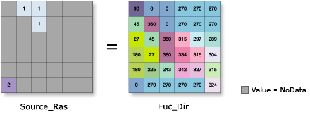
Calculates, for each cell, the Euclidean distance to the closest source.
Tip:
The Distance Accumulation function provides enhanced functionality or performance.
The direction is calculated from each cell center to the center of the source cell that's nearest to it.
The range of values is from 0 degrees to 360 degrees, with 0 reserved for the source cells. Due east (right) is 90 and the values increase clockwise (180 is south, 270 is west, and 360 is north).

Learn more about Euclidean distance analysis
This is a global raster function.
Notes
The input source data must be a raster layer.
The NoData values that exist in the Source Raster are not included as valid values in the function. The value 0 is considered a legitimate value in the source raster. A Source Raster can be created using the extraction tools or the Clip function.
If you have source features, you can first convert them to a raster dataset using the Rasterize Features function. Use a consistent input for the Raster input to that function. This will ensure that the features are properly converted to a raster dataset using the same cell size, extent, and spatial reference.
The Maximum Distance is specified in the same map unit as the Source Raster.
If the Mask has been set in the geoprocessing environments, and the cells to be masked will cover a source location, the Euclidean calculations will occur on the remaining source locations. The source cells that are masked will not be considered in the computations; these cells will be assigned a value of NoData. Any cell location that is assigned NoData on the input surface will receive NoData on all the output rasters. See Analysis environments and Spatial Analyst for additional details on the geoprocessing environments that apply to this function.
Parameters
| Parameter | Description |
|---|---|
Source Raster (Required) | A raster dataset that identifies the cells or locations to which the Euclidean direction for every output cell location is calculated.. The input type can be an integer or a floating-point type. |
Raster Barriers | The raster that defines the barriers. The dataset must contain NoData where there are no barriers. Barriers are represented by valid values including zero. The barriers can be defined by an integer or a floating-point raster. |
Maximum Distance | Defines the threshold distance within which the direction to the closest source will be calculated. If the distance to the nearest source exceeds this, the output for that cell will be NoData. The default distance is to the extent of the output raster. |
Cellsize | The cell size at which the output raster will be created. If the cell size was explicitly set in Environments, that will be the default cell size. If it was not set, the output cell size will be the same as the Source Raster. |
Distance Method | Determines whether the distance will be calculated using a planar (flat earth) or a geodesic (ellipsoid) method.
|
Environment settings
Geoprocessing environment settings for global functions are controlled at the application level. Setting processing environments in ArcGIS Pro can be done by clicking the Environments button on the Analysis tab. See Analysis environments and Spatial Analyst for additional details on environment settings.
The following environments are supported by this global function: