Overview
Map Algebra is a way to perform spatial analysis by creating expressions using algebraic operators. With the Calculator function, you can create and run expressions and incorporate them into raster function templates.
License:
The following operators are available with all license levels: plus, minus, times, divide, and power. All other operations require either the ArcGIS Image Analyst extension or the ArcGIS Spatial Analyst extension.
Notes
This function provides access to all existing math functions so you can make calls to them when building your expressions. To assist you, autocomplete is built in to provide access to the operators as well as the math functions.
The available operators are listed in the table below.
Arithmetic Operations
| Operation | Symbol |
|---|---|
Plus | + |
Divide | / |
Modulo | % |
Times | * |
Power | ** |
Minus | - |
Boolean Operations
| Operation | Symbol |
|---|---|
Boolean And | && |
Boolean Or | || |
Relational Operations
| Operation | Symbol |
|---|---|
Equal to | == |
Greater than | > |
Greater than or Equal to | >= |
Less than | < |
Less than or Equal to | <= |
Not Equal to | != |
Trigonometric Operations
| Operation | Symbol |
|---|---|
ACos | ACos(a) |
ACosH | ACosH(a) |
ASin | ASin(a) |
ASinH | ASinH(a) |
ATan | ATan(a) |
ATan2 | ATan2(a) |
ATanH | ATanH |
Cos | Cos(a) |
CosH | CosH(a) |
Sin | Sin(a) |
SinH | SinH(a) |
Tan | Tan(a) |
TanH | TanH(a) |
Additional Operations
| Operation | Symbol |
|---|---|
Con | Con(a,b,c) |
Is Null | IsNull(a) |
Minimum of two rasters on a per-pixel basis | min(a,b) |
Maximum of two rasters on a per-pixel basis | max(a,b) |
Set Null | SetNull(a,b) |
Parameters
| Parameter name | Description |
|---|---|
| Raster Variables | The user-defined variable name and the input raster. |
| Expression | Build an algebraic expression to perform spatial analysis on the input raster. |
| Cellsize Type | Choose which cell size to use in the output raster. If all the input cell sizes are the same, all the options will yield the same results.
|
| Extent Type | Choose which extent should be used in the output raster:
|
Examples of expressions
Expressions can be a simple one line of code, or it can be a several lines of code.
Simple Conditional Statement
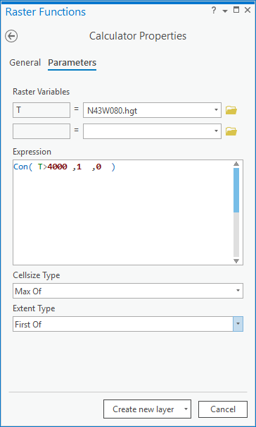
Find elevation values above 4,000 feet. Give these areas a value of 1 and all other areas a value of 0.

Nested Conditional Statement
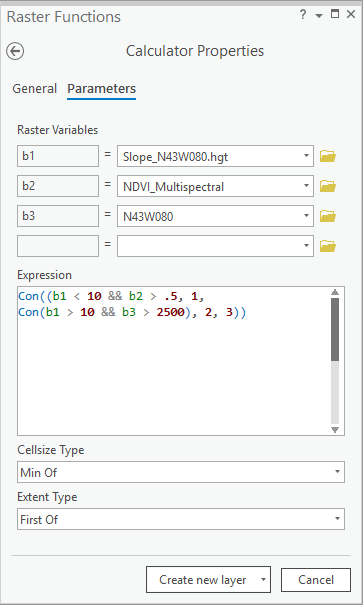
Find areas where slope is below 10 degrees and NDVI is above 0.5. Give these areas a value of 1. For all other areas, assign a value of 2 if slope is above 10 degrees and elevation is over 2,500 feet. All other areas are assigned a value of 3.
