Available with the ArcGIS Indoors Pro or ArcGIS Indoors Maps extension.
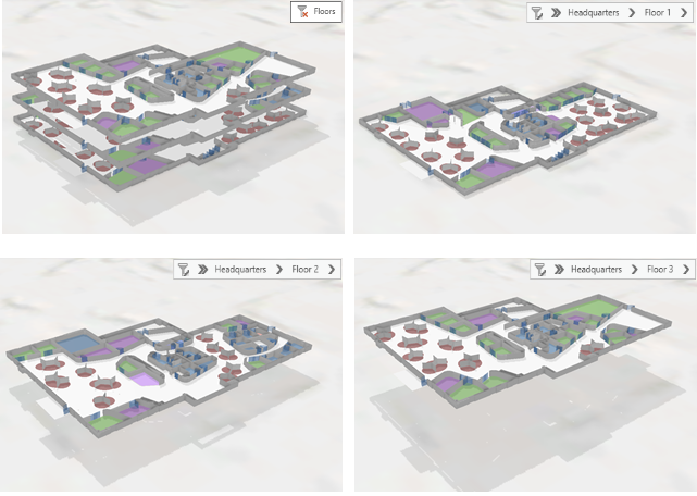
Floor-aware maps and scenes contain indoor GIS data representing floor plan features. These features are organized hierarchically, with features associated to a level, levels associated to a facility, and facilities associated to a site. ArcGIS Pro, other apps, and APIs that support floor-aware maps and scenes can use these associations to enable intuitive visualization and analysis of indoor data. For example, you can use floor-aware maps to do the following:
- Visualize space use in a large office building to determine where changes to office assignments could improve team proximity and conserve resources.
- Track wheelchairs, mobile defibrillators, and other critical assets in a medical facility to help staff identify the nearest available resources and the quickest route to reach them.
A floor-aware map or scene must include, at a minimum, a layer representing facilities and a layer representing levels. These layers must include specific fields that identify the features and define their hierarchical relationships, such as the levels associated with a given facility. A map or scene becomes floor-aware when these layers are specified on the Indoor Layers tab of the Map Properties dialog box.
You can optionally set the map's indoor layers properties to use a polygon layer representing sites, such as college campuses, to define collections of facilities. Units (such as rooms or hallways), architectural details (such as doors, walls, restroom stalls, or windows), objects (such as assets, hardware, or equipment), work orders, and other point, line, and polygon feature data can become floor-aware if the features have an associated level. You can define these additional layers as floor aware by setting the layer's Floor Field property.
You can share a floor-aware web map that contains feature service layers or map image layers. The following sharing configurations are supported:
- Reference registered data—Editable
- Reference registered data—Exploratory
- Copy all data—Exploratory
- Copy all data—Editable
Note:
If you open a web map shared with the Reference registered data—Exploratory configuration method in ArcGIS Pro, you can access the web map's Indoor Layers properties, but you cannot edit them.
You can share a floor-aware web scene that contains feature service layers or scene service layers. The following data and layer types are supported:
- Reference registered data—Scene
- Copy all data—Scene
Note:
Web scene layers cached on the server are not supported on ArcGIS Enterprise on Kubernetes 11.2.
Schema requirements
An indoor dataset created using tools available with the ArcGIS Indoors license provides a well-defined schema for loading and maintaining floor plan data in an indoor GIS. The schema includes feature classes that you can use to configure a floor-aware map or scene.
You can define additional feature layers as floor aware as long as they contain an attribute field that defines the level on which each feature is located. This allows you to relate data to the floor plan from other business systems that may have a schema that differs from the Indoors model.
Floor filter
Once you define a map or scene as floor aware in the map's properties, you can use an interactive floor filter to explore floor-aware data based on the configured sites, facilities, and floors layers.
The floor filter allows you to filter the floor plan data displayed in a map or scene by site, facility, and level. It can also filter additional data such as architectural details, assets, or work orders that include level information and are configured as floor-aware layers. For example, you can filter a map with multiple campuses to visualize a single campus, a facility on that campus, and all the floor-aware features on a specific floor of that facility.

The floor filter works in conjunction with other filters to further control visualization, such as definition queries, selection, range, and time. For example, you can visualize which conference rooms on a level have events scheduled for a given time span. You can interactively select features filtered by the floor filter to use in subsequent exploration, analysis, and editing of the data. You can also use the floor filter to create layouts for the data and export the layout to print or share your work.
Supported layer and geometry types
You can define layers as floor-aware from file and enterprise geodatabases, feature services, or external systems for features such as assets, work orders, occupants, or events.
You can configure sites, facilities, and floors in a map's indoor layers properties for layers with a polygon geometry type. You can configure the indoor layers properties for scenes using feature layers with either a polygon or multipatch geometry type.
Additional layers can be configured as floor-aware by setting the Floor Field property on the Floors tab of the Layer Properties dialog box. The following geometry types are supported for floor-aware layers:
- Point (maps and scenes)
- Line (maps and scenes)
- Polygon (maps and scenes)
- Multipatch (scenes only)
- Oriented Imagery (maps and scenes)
You can set floor-aware properties in ArcGIS Pro for maps or scenes and publish them to your ArcGIS organization. You can also set or modify floor-aware properties for published feature layer-based web maps and web scenes, existing layers, or newly added layers.