Сводка
Removes unwanted cutbacks for polyline and polygon feature classes or layers.
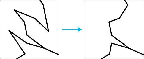
Cutbacks are high-angle turns that cause features to turn back toward themselves. These angles affect polyline and polygon features and can be caused during an editing session. For example, through a digitizing error, a river feature may have a short segment (less than one meter) that turns back toward itself and back in the original direction again.
Иллюстрация

Использование
- If the angle formed by a vertex and its two neighboring points is smaller than the Minimum Angle, the vertex is a candidate for cutback removal.
When Skip vertices coincident between multiple features is selected, the vertices that have angles smaller than the Minimum Angle will not be removed from the feature geometry if they touch another feature in the Input Features.
If you have performed edits on features in your map prior to running a geoprocessing tool, you can undo the results of the tool. If you haven't performed any edits prior to running the tool, you cannot undo the results of a tool.
Внимание:
This tool modifies the input data. See Tools that do not create output datasets for more information and strategies to avoid undesired data changes.
Синтаксис
arcpy.topographic.RemoveCutbackVertices(in_features, minimum_angle, {removal_method}, {skip_coincident_vertices})| Parameter | Объяснение | Тип данных |
in_features | The polyline or polygon feature class from which the tool will remove cutback vertices. This feature class (or layer) will be modified. | Feature Layer |
minimum_angle | The minimum angle threshold value (in degrees). The angle value should be within the range of 0–180. If the angle formed by a vertex and its two neighboring points is below the specified minimum angle, the vertex is a candidate for cutback removal. | Double |
removal_method (Дополнительный) | Indicates whether cutbacks should be removed one at a time or all at once.
| String |
skip_coincident_vertices (Дополнительный) | Indicates whether to Remove Cutback Vertices when the vertex is snapped to another feature within the same feature class.
| Boolean |
Производные выходные данные
| Name | Объяснение | Тип данных |
| updated_features | Polygon or polyline features with cutbacks removed. | Feature Layer |
Пример кода
The following stand-alone sample script demonstrates how to use the RemoveCutbackVertices tool to ignore cutbacks that are snapped to a feature.
# Name: RemoveCutbackVertices_sample.py
# Description: Determines a cutback in a line or polygon based on a provided angle and repairs it.
# In this example, the tool will ignore any cutbacks that are snapped to a feature to avoid creating gaps.

# Import System Modules
import arcpy

# Check Out Extensions
arcpy.CheckOutExtension("Foundation")

# Set workspace
arcpy.env.workspace = r'C:\Data\Editing_Sample.gdb'

# Setting Local Variables
roads = r"Roads"
minimum_angle = "25"
removal_type = 'SEQUENTIAL'
skip_coincident_vertices = 'REMOVE_COINCIDENT'

# Execute Remove Cutback Vertices
arcpy.RemoveCutbackVertices_topographic(roads, minimum_angle, removal_type, skip_coincident_vertices)

# Check In Extensions
arcpy.CheckInExtension("Foundation")
Environments
Информация о лицензиях
- Basic: Нет
- Standard: Требуется Production Mapping
- Advanced: Требуется Production Mapping