public static Polyline CreatePolyline(
   MapPoint startPoint,
   double startTangentDirection,
   double startRadius,
   double endRadius,
   esriArcOrientation orientation,
   esriClothoidCreateMethod createMethod,
   double lengthOrAngle,
   esriCurveDensifyMethod densifyMethod,
   double curveDensity,
   SpatialReference spatialReference
)
Public Overloads Shared Function CreatePolyline( _
   ByVal startPoint As MapPoint, _
   ByVal startTangentDirection As Double, _
   ByVal startRadius As Double, _
   ByVal endRadius As Double, _
   ByVal orientation As esriArcOrientation, _
   ByVal createMethod As esriClothoidCreateMethod, _
   ByVal lengthOrAngle As Double, _
   ByVal densifyMethod As esriCurveDensifyMethod, _
   ByVal curveDensity As Double, _
   Optional ByVal spatialReference As SpatialReference _
) As Polyline
Parameters
- startPoint
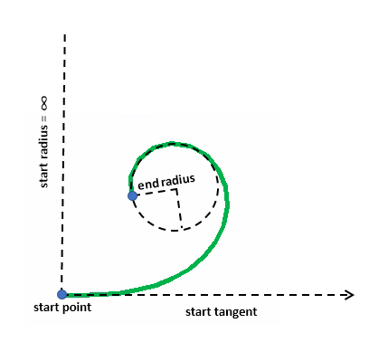
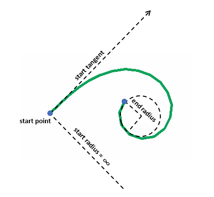
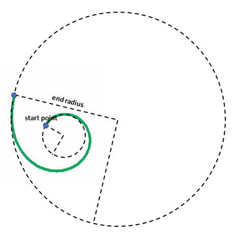
- The start point of the polyline.
- startTangentDirection
- The tangent direction of the spiral, north azimuth, at the first point of the spiral. The unit of the azimuth is radians.
- startRadius
- The radius at the start of the spiral. The radius must be greater than zero. Double.Infinity is a valid value for the radius.
- endRadius
- The radius at the end of the spiral. The radius must be greater than zero. Double.Infinity is a valid value for the radius.
- orientation
- The orientation of the spiral.
- createMethod
- The method of creation. esriClothoidCreateMethod.ByLength signifies that lengthOrAngle specifies the length of the entire spiral. esriClothoidCreateMethod.ByAngle signifies that lengthOrAngle specifies the angle, in radians, measuring the span of the arc from the start to the end of the clothoid path.
- lengthOrAngle
- Either the length of the clothoid or the central angle of the clothoid as specified by createMethod.
- densifyMethod
- The method of densification.
- curveDensity
- If densifyMethod is esriCurveDensifyMethod.ByLength, then curveDensity is the maximum segment length allowed in the clothoid. If densifyMethod is esriCurveDensifyMethod.ByDeviation, then curveDensity is the maximum distance, in meters, that the clothoid can deviate from the actual curve. If densifyMethod is esriCurveDensifyMethod.ByAngle, then curveDensity is the maximum angle between tangent lines to the curve.
- spatialReference
- (Optional) The spatial reference of the polyline. The default value is null.