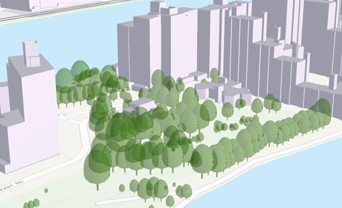
A scene layer is a type of layer that is optimized for displaying large amounts of 3D data in a scene. A scene layer displays one of five data types: points, point cloud , 3D object , building, or an integrated mesh. The scene layer complies with the Indexed 3D Scene layer (I3S) format. The I3S format is an open 3D content delivery format used to disseminate 3D GIS data to mobile, web, and desktop clients.
Visualizing your information in 3D makes it easier to intuitively understand and experience geographic information in a realistic way. Even audiences unfamiliar with GIS can understand complex and detailed data by viewing it in a 3D scene on the web. Being able to capture the three-dimensional nature of objects in the real world allows you to analyze, measure, and query information with more precision. For example, you can analyze the development impact on a community or the impact of flooding.
You can use scene layers in many different scenarios from 3D basemaps to modelling urban areas by visualizing buildings, trees, or bridges. The amount of detail in a scene layer will depend on your needs. For example, a building can be represented as a 3D object scene layer showing the outer shell of a building or as a building scene layer including all assets within the building, such as furniture or light fixtures.
Scene layers are used by many ArcGIS applications such as Scene Viewer, ArcGIS Earth, and ArcGIS Pro.
When shared to ArcGIS Enterprise or ArcGIS Online, a scene layer becomes a web scene layer. Scene layers are cached to improve drawing performance. The cache contains different levels of detail (LODs); which LOD is used depends on the distance at which the data is being viewed. This means that when you zoom out and increase the distance to your features, the complexity of the 3D data is decreased as well.
Below are common capabilities you can use with each type of scene layer.
Scene Layer Capabilities
| Functionality | 3D object | Building | Integrated mesh | Point | Point cloud |
|---|---|---|---|---|---|
Symbology | RGB textures | ||||
Labeling | Not available | Not available | |||
Query | Not available | ||||
Pop-ups | Not available | ||||
Editing | Not available | Not available | |||
Geoprocessing | Clip, Project, Line of Sight, Intervisibility, Extract Multipatch from Mesh |
Work with web scene layers
You can share scene layers to ArcGIS Online or ArcGIS Enterprise. Depending on the way the scene layer has been created, different capabilities are available for the different scene layer types.
Web scene layers from a scene layer package
A scene layer package (.slpk) contains the scene layer cache that can be published as a web scene layer. Use the Validate Scene Layer Package geoprocessing tool to evaluate a scene layer package file to determine its conformity to I3S specifications. Web scene layers generated from a scene layer package are shared from ArcGIS Pro by selecting the option to cache locally when configuring the web scene layer. For more information on sharing web scene layers, see Share a web scene layer. They can additionally be shared using the Create Building Scene Layer Package, Create Point Scene Layer Package, Create Point Cloud Scene Layer Package , Create 3D Object Scene Layer Package , Create Integrated Mesh Scene Layer Package, and the Share Package geoprocessing tools.
Web scene layers with associated feature layers
Feature-based scene layers such as 3D object, building, or point scene layers can retain the connection to the feature layer the scene layer was created from. For example, if all your building information is persisted in a multipatch feature class in your enterprise geodatabase, you can share by reference. The scene layer, together with the associated feature, build a unit, allowing you to maintain the scene layer by editing the geometry and attributes. Web scene layers that have an associated feature layer provide dynamic statistical information that you can use for symbology or definition queries. When you access the attribute table of the scene layer, the table from the associated feature layer will be displayed.
The following table lists the ways to create and share a web scene layer.
| Source | Share As | Published Layer |
|---|---|---|
Scene Layer Package | Web scene Share package tool | Web scene layer |
Point Layer, 3D Object Feature Layer, Multipatch Layer, Building Layer | Web layer or web scene layer with feature option checked | Web scene layer with associated feature layer |
Point Layer, 3D Object Feature Layer, Multipatch Layer, Building Layer | Web layer or web scene layer with feature option unchecked | Web scene layer |
3D object scene layers
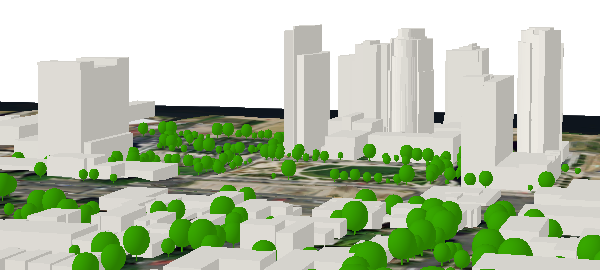
A 3D object scene layer can be used to represent and visualize objects such as buildings that are explicitly modeled in three dimensions. A 3D object scene layer is typically used to create large city models that can be shared. The objects can be displayed with textures or with color symbology, depending on the content that is being visualized. A 3D object scene layer is a true 3D object and only absolute height can be defined in the elevation properties.
Building scene layers
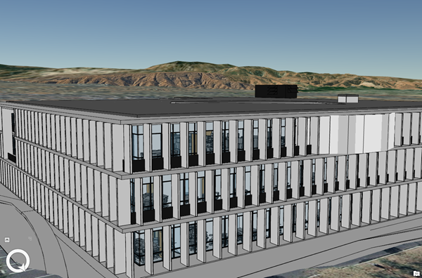
Building scene layers allow you to share building information across the ArcGIS platform. Building information is derived from a BIM (Building Information Modeling) model representing buildings. In the current release, you can use Revit data or feature classes created from the BIM File To Geodatabase geoprocessing tool to create a building scene layer.
Integrated mesh scene layers
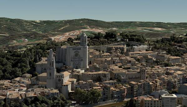
Three-dimensional mesh data is typically captured by an automated process for constructing 3D objects out of large sets of overlapping imagery. The result integrates the original input image information as a textured mesh including 3D objects, such as buildings and trees, and elevation information. Integrated mesh scene layers are generally created for citywide 3D mapping. They are often captured by drone and cannot be restyled.
Point cloud scene layer
Point cloud scene layers provide fast display of large volumes of symbolized and filtered point cloud data. They are optimized for the display and sharing of many kinds of sensor data, including lidar. Point cloud scene layers help share 3D point cloud content across the platform.
Point scene layers
To ensure fast visualization in all clients, cached point scene layers are used to display large amounts of point data in ArcGIS Pro and a web scenes. For example, you can use a scene layer to display the trees in a city using preset layers.
Point scene layers are automatically thinned to improve performance and visibility at greater distances. Automatic thinning means that not all features are displayed at greater distances. As you zoom in, additional features are displayed until you reach the highest level of detail, when all points will be shown.
