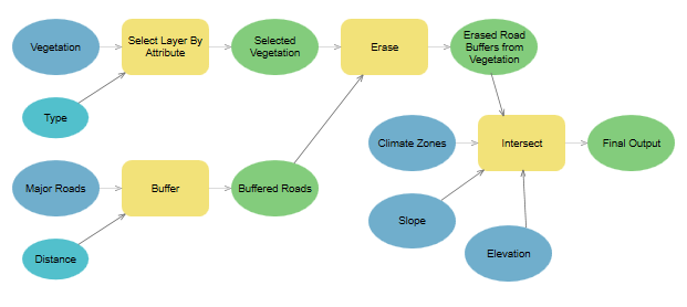
ModelBuilder is a visual programming language for building geoprocessing workflows. Geoprocessing models automate and document your spatial analysis and data management processes. You create and modify geoprocessing models in ModelBuilder, where a model is represented as a diagram that chains together sequences of processes and geoprocessing tools, using the output of one process as the input to another process.
ModelBuilder in ArcGIS Pro allows you to do the following:
- Build a model by adding and connecting data and tools.
- Iteratively process every feature class, raster, file, or table in a workspace.
- Visualize your workflow sequence as an easy-to-understand diagram.
- Run a model step by step, up to a selected step, or run the entire model.
- Make your model into a geoprocessing tool that can be shared or can be used in Python scripting and other models.
Learn more about using ModelBuilder
Example
This geoprocessing model is used by a conservation organization to identify potential habitats for an indigenous bird species based on vegetation type, distance from major roads, climate, slope, and elevation. 
- Select Layer By Attribute—Select the correct vegetation type from a Vegetation map layer.
- Buffer—Create areas within a distance of 1,500 feet around major roads.
- Erase—Erase the buffer areas from the selected vegetation areas.
- Intersect—Overlay the output of the Erase tool with other map layers, including slope, elevation, and climate. This identifies the areas that meet all criteria.
