Hyperspectral imagery is a type of remote sensing technology that captures and analyzes information from across the electromagnetic spectrum in numerous, narrowly defined wavelength bands. Airborne and satellite hyperspectral sensors collect imagery data across hundreds, or even thousands, of contiguous spectral bands, each representing a very narrow range of wavelengths. The high spectral resolution of hyperspectral imagery allows objects and materials to be identified based on their unique spectral signature and other analytical characteristics.
ArcGIS supports hyperspectral images stored in standard raster formats, such as TIFF and ENVI formats, as well as EMIT imagery stored in NetCDF, and AVIRIS imagery stored in ENVI format. Since not all these formats can be browsed or drag-and-dropped as regular raster datasets in the Catalog pane, a common way to add hyperspectral data to a map is by using the Add Data  button.
To add hyperspectral data to a map or scene, complete the following steps:
- Click the Map tab on the ArcGIS Pro ribbon.
- In the Layer group, click the Add Data drop-down list, and select Hyperspectral data.
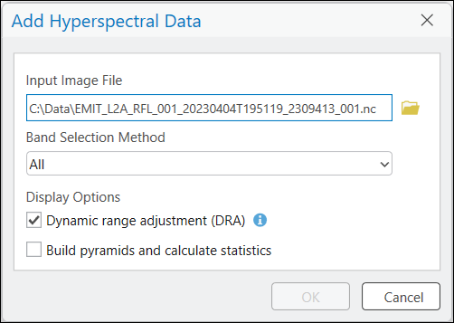
The Add Hyperspectral Data dialog box appears.

- Provide the path to the hyperspectral data that you want to add to the map.
- Add all bands (recommended), or a subset of bands, using the following band selection methods:
- All—Use this option to add the data with all bands.
- Band Wavelengths—Specify the minimum and maximum band wavelengths.
- Band IDs—Specify the minimum and maximum band IDs.
- Band Names—Choose one or more bands.
- Check the Dynamic range adjustment (DRA) checkbox.
The DRA option calculates statistics using only the 3 bands within the map display, and applies the stretch accordingly.
- Optionally, check the Build pyramids and calculate statistics checkbox.
When checked, statistics will be calculated and pyramids built for the entire hyperspectral dataset. The skip factors used for calculating statistics are 10 rows and 10 columns. The parameters used for building pyramids are nearest neighbor for resampling, and LZ77 for compression. Expect the process to take a significant amount of time, depending on the size and number of hyperspectral bands.
- Click OK to add the hyperspectral imagery to the map.