Spatial analysis allows you to solve complex location-oriented problems, explore and understand your data from a geographic perspective, determine relationships, detect and quantify patterns, assess trends, and make predictions and decisions. Spatial analysis goes beyond mapping and allows you to study the characteristics of places and the relationships among them. Spatial analysis lends new perspectives to your decision-making.
Using spatial analysis, you can combine information from many sources and derive new information by applying a set of spatial operators. This collection of spatial analysis tools allows you to answer complex spatial questions. Statistical analysis can determine whether the patterns that you see are significant. You can analyze various layers to calculate the suitability of a place for a particular activity and, using image analysis, you can detect change over time. These tools allow you to address important questions and decisions that are beyond the scope of simple visual analysis.

You can use the analysis and geoprocessing capabilities in ArcGIS Pro to answer many spatial questions and perform spatial analysis. Spatial analysis in ArcGIS Pro is extended from 2D to 3D and through time.
A typical spatial analysis workflow involves the following:
- Frame the question you want to answer.
- Find and prepare the data using data engineering to ready it for analysis.
- Explore the data on a map and with charts to better understand it.
- Perform the spatial analysis, using the appropriate tool or set of tools to answer the question.
- Repeat or automate the analysis using modeling and scripting.
- Share the results to communicate findings or allow others to repeat the process.
Data engineering
Using data engineering, you can explore, visualize, clean, and prepare data. The data engineering process is a common first step for many spatial analysis and mapping workflows. The Data Engineering view and ribbon can help you better understand the data and prepare it for GIS workflows.
Visualization with charts
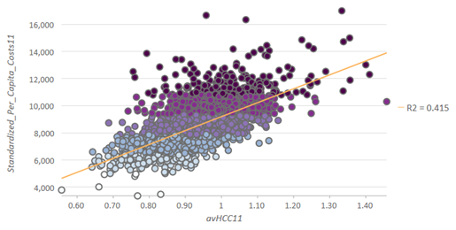
Visualizing data using charts can uncover data patterns, trends, relationships, and structures that may otherwise be difficult to see as raw numbers in a table. Interpret the results of an analysis and communicate the findings with charts.

Spatial analysis
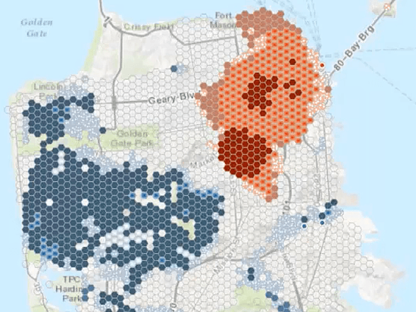
Using spatial analysis capabilities in ArcGIS Pro, you can perform the following types of operations on geographic data:
- Extract and overlay data.
- Add and calculate attribute fields.
- Summarize and aggregate data.
- Calculate statistics.
- Model relationships and discover patterns.
Learn more about geoprocessing
Learn more about raster functions
Analysis extensions
ArcGIS Pro includes the following analysis extensions to help you answer specialized spatial questions:
- 3D Analyst—Analyze and create 3D GIS data and perform 3D surface operations using rasters, TINs, terrains, and LAS datasets (lidar).
- Business Analyst—Analyze market trends, including customer and competitor analysis, site evaluation, and territory planning.
- Geostatistical Analyst—Analyze and predict the values associated with spatial or spatiotemporal phenomena.
- Image Analyst—Interpret and use imagery, perform feature extraction and measurement, and perform classification and object detection using machine learning.
- Network Analyst—Measure distances and travel times along a network to find a route between multiple locations, create drive-time buffers or service areas, and find the best locations for facilities to serve a set of locations.
- Spatial Analyst—Find the most suitable locations, calculate distance and determine optimal paths by incorporating the cost of travel, analyze and interpolate surfaces, calculate density, conduct hydrologic analysis, perform statistical analysis, and perform various raster-based mathematical operations.
Machine learning and artificial intelligence
Machine learning refers to a set of data-driven algorithms and techniques that automate the prediction, classification, and clustering of data. Deep learning is an important subset of machine learning techniques that uses artificial neural networks to learn from data. Machine learning and deep learning can play an important role in spatial problem solving in a wide range of application areas, from image classification to spatial pattern detection to multivariate prediction.
In addition to traditional machine learning techniques, ArcGIS Pro includes a subset of machine learning techniques that are inherently spatial. These spatial methods that incorporate geography directly into their computation can lead to better understanding. The spatial component often takes the form of a measure of shape, density, contiguity, spatial distribution, or proximity. Both traditional and inherently spatial machine learning can play an important role in solving spatial problems, and ArcGIS Pro supports their use in a number of ways.
Machine learning can be computationally intensive and often involves large and complex data. Advancements in data storage and parallel and distributed computing make solving problems related to both machine learning and GIS possible.
The following capabilities and tools use machine learning and deep learning:
- The Mapping Clusters toolset and Modeling Spatial Relationships toolset in the Spatial Statistics toolbox
- The Time Series Forecasting toolset in the Space Time Pattern Mining toolbox
- Feature, tabular, and text analysis tools in the GeoAI toolbox
- The Multidimensional Analysis toolset and Deep Learning toolset in the Image Analyst toolbox
- The Point Cloud toolset in the 3D Analyst toolbox
- The interactive deep learning-based object detection tool
Big data analytics
ArcGIS Pro includes tools that can transform large amounts of spatial data into manageable information. Using parallel processing on a single machine or distributed processing with multinode servers, you can analyze and gain insights from large volumes of data that were previously too large or complex.
You can use the following capabilities and toolboxes to analyze big data:
- The GeoAnalytics Desktop toolbox provides a parallel processing framework for analysis on a desktop machine using Spark. Through aggregation, regression, detection, and clustering, you can visualize, understand, and interact with feature and tabular big data. These tools work with big datasets and allow you to gain insight into the data through patterns, trends, and anomalies.
Learn more about the GeoAnalytics Desktop toolbox
Tools in the Movement Analysis toolset in the AllSource toolbox also use Apache Spark.
- The GeoAnalytics Server toolbox provides the same capabilities as the GeoAnalytics Desktop toolbox but the tools scale to analyze even larger datasets using ArcGIS GeoAnalytics Server to distribute the analysis between multiple server nodes.
- The Raster Analysis toolbox contains tools for performing computationally intensive raster analysis on image services and other portal items. Large imagery and raster collections can be processed using raster analytics in ArcGIS Image Server by distributing the processing between multiple server nodes. Analytical capabilities include image processing, deep learning, distance analysis, surface analysis and interpolation, density calculation, hydrologic analysis, spatial and temporal analysis of multidimensional data, and statistical and mathematical operations.
Learn more about the Raster Analysis toolbox
- You can perform visual analytics and data exploration of big data in a cloud data warehouse or other enterprise source using charts.
- Dynamically bin big data and display it on a map to aggregate and summarize the data on the fly without preprocessing steps.
Modeling and scripting
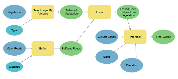
Save time on repetitive tasks, minimize errors, and iterate analysis efficiently by creating models or scripts. Then turn a model or script into a custom tool. Use Python to script workflows or build models of workflows using ModelBuilder.

You can also add third-party libraries using the Package Manager to extend ArcGIS Pro.
Sharing and collaboration
You can share the analysis methodology as well as the data you have analyzed in ArcGIS Pro with your colleagues, organization, or community as geoprocessing packages or web tools. With these shared analysis tools, anyone can take advantage of your expertise in spatial analysis while performing the analysis themselves.