Information associations can be used to add spatial quality, contact details, or other attributes that are not directly encoded to the feature itself. You can create information associations using the Association Manager tool, available on the Maritime S-100 tab. You must have write access to the geodatabase to create or append information associations.
Note:
When creating an information association using the Spatial Quality information type, you must first create a referenced geometry that the spatial quality attributes can be associated with.
Create information records
Before you can create an information association, you must create the information records that you want to associate features to. Information records are based on the various information types described in S-100 specifications, such as Spatial Quality or Nautical Information. These information records can be associated with one or more features to provide supplemental information for those features. You can create an information record that is generic and used across multiple products, as well as information records that are specific to particular products or features.
Note:
In S-100 specifications, information types do not have geometry; however, the information feature is assigned a geometry in a maritime S-100 database to store and manage the association to features. The geometry of information types is not exported to S-100 datasets.
The extent of an information record is determined by its geometry and compilation scale values. The compilation scale should include the minimum and maximum compilation scale of the features that you want to associate it with. When creating a generic information record that applies to multiple products, the compilation scale values must include all scales that it should be extracted to.
To create an information record, complete the following steps:
- Open or create a project in ArcGIS Pro.
- Connect to a maritime database containing S-100 data or create a maritime geodatabase that uses an S-100 schema and import S-100 data, if necessary.
- Add the following to the map, if necessary:
- Feature classes for the information types you want to create
- Feature classes for the features that you want to create information associations for
The Maritime S-100 tab appears.
If the database was created using a subtyped data model such as the model defined by the S-101FeatureClassMap.xml mapping file provided with the ArcGIS Maritime product files, information types are stored in the InformationRecords feature class. If your database uses a flat data model, each information type is stored in its own feature class.
- On the Maritime S-100 tab, in the S-100 Editing group, set the compilation scale values.
Make sure the compilation scale range is within the compilation scale values of the features that you want to associate the information record with.
- On the Maritime S-100 tab, in the Features group, click Create
 .
. The Create Features pane appears.
- On the Templates tab, choose the template for the information type that you want to create, such as SpatialQuality or NauticalInformation.
The chosen template is expanded.
- Click the Rectangle tool
 .
. - Draw a rectangle that covers the area for which the information record is applicable.
- Double-click or press F2 to complete the sketch.
- On the Maritime S-100 tab, in the Selection group, click Attributes
 .
. - In the Maritime Attributes pane, under S-101 Attributes, provide values for the required attributes, and, if needed, for any optional attributes.
- Click Apply to save the attribute values.
- On the Maritime S-100 tab, in the Manage Edits group, click Save
 .
.
The information record is created and you can use it to create information associations.
Associate features with information records
Once you have created information records, you can use the Association Manager tool to create information associations. To create information associations, complete the following steps:
- From an S-100 database, add the following to the map, if necessary:
- Feature classes for the features that you want to create information associations for
- Feature classes for the information types you want to associate with features
The Maritime S-100 tab appears.
- In the S-100 Editing group, set the compilation scale values.
Make sure the minimum compilation scale and the compilation scale range includes the compilation scale of the features you want to associate the information record with.
- On the Maritime S-100 tab, in the S-100 Editing group,
click Association Manager
 .
.The Association Manager pane appears.

Before creating associations, ensure that the features you want to associate are visible in the map view.
- Select the features on the map that you want to create information associations for.
You can either select features on the map or identify features by extent and use the context menu options to select features.
Note:
To create Spatial Associations using the Spatial Quality information type, select the reference geometries that are related to the features you want to create associations for.
- In the View Associations By section, choose Selection.
Tip:
To view all features in the extent, choose Extent. Check the Show Only Existing check box to view features with existing associations.
- Click Refresh
 to update the Association Manager pane.
Features that are selected in the map appear in the list.
- Expand the S-100 type node to view individual features.
Features that are selected appear in the list.
- Expand a geodatabase feature node to build associations.
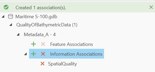
In the example below, the S-100 type is QualityOfBathymetricData and the geodatabase feature node is Metadata_A - 4.

Tip:
Open the Attributes pane to view S-101 Attributes for the features you want to associate.
- Under the feature that you want to associate, next to Information Associations, click Associate Selected Features
 .
.The association is created and a record is stored in the InformationAssociations feature class.

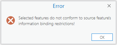
If you try to associate a feature to an information type it cannot be associated with, the following error message appears:

Refer to the S-100 Feature Catalogue used to create the database to determine valid information bindings.
- Expand the association to review the associated features.
You can hover over an associated feature to verify the role of the association and the GUID of the associated feature.

- On the Maritime S-100 tab, in the Manage Edits group, click Save
 .
.
The association is saved to the geodatabase in the active workspace.