A chart is a graphical representation of data. Visualizing data through charts helps to uncover patterns, trends, relationships, and structure in data. Use charts together with maps to explore data and help tell a story.
Charts can be created from both tabular and raster data, and a different set of charts are available for each data type. Tabular data refers to vector or feature data, as well as stand-alone tables. Raster data refers to imagery or pixel-based data.
In ArcGIS Pro, you can do the following:
- Create a chart of any map layers with tables, rasters, or stand-alone tables.
- Interact with charts to explore data dynamically across related maps, tables, and other charts created from the same layer.
- Change a chart's appearance and save or apply custom format themes.
- Manage the charts associated with the layers in your maps.
- Share a chart by exporting it as a graphic; adding it to a layout; or packaging its source layer, map, or project.
- Use the arcpy.charts module to programmatically create, configure, and export charts.
Example
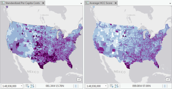
Below are two maps of United States counties showing information about Medicare beneficiaries in 2011. The first map shows variation in Medicare spending per capita. The second map shows variation in the overall health of the population. Through a visual comparison, you can get a sense of the relationship between the two variables by noting where the maps have similarities and differences.

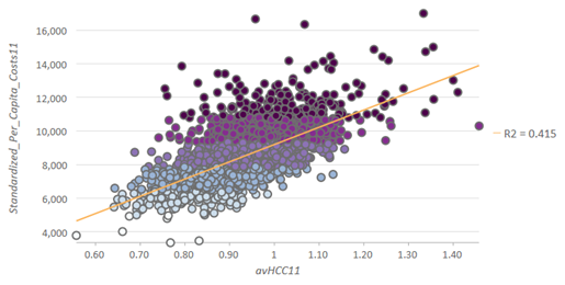
By creating a scatter plot of the same variables, the relationship between Medicare spending and the health of the population is more clearly shown. The positive relationship between the two variables is shown by the upward slope of the trend line. The R2 value shows that the health of the population is roughly 41.5 percent of the variation in Medicare spending per capita.
