Disponible avec une licence Geostatistical Analyst.
Three of the kriging methods—ordinary, simple, and universal—use measurement error models. Measurement error occurs when it is possible to have several differing observations at the same location. For example, you might extract a sample from the ground or air and divide that sample into several subsamples to be measured. You may want to do this if the instrument that measures the samples has some variation. As another example, you might send subsamples of a soil sample to different laboratories for analysis. There could be other times when the variation in instrument accuracy is documented. In this case, you may want to input the known measurement variation into your model.
The measurement error model
The measurement error model is
Z(s) = µ(s) + ε(s) + δ(s),where δ(s) is measurement error and µ(s) and ε(s) are the mean and random variation. In this model, the nugget effect is composed of the variance of ε(s) (called microscale variation) plus the variance of δ(s) (called measurement error). In Geostatistical Analyst, you can specify a proportion of the estimated nugget effect as microscale variation and measurement variation, have Geostatistical Analyst estimate measurement error for you if you have multiple measurements per location, or input a value for measurement variation. When there is no measurement error, kriging is an exact interpolator, meaning that if you predict at a location where data has been collected, the predicted value is the same as the measured value. However, when measurement errors exist, you want to predict the filtered value, µ(s0) +ε(s0), which does not have the measurement error term. At locations where data has been collected, the filtered value is not the same as the measured value.
In previous versions of ArcGIS, the default measurement variation was 0%, so kriging was defaulted to be an exact interpolator. In ArcGIS 10, the default measurement variation is set to 100%, so the default predictions at measured locations will be based on the spatial correlation of the data and the measured values at nearby locations. Measurement error can be introduced by many sources, including uncertainty in the measurement device, location, and data integration. In practice, perfectly precise data is extremely rare.
The effect of the model
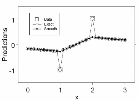
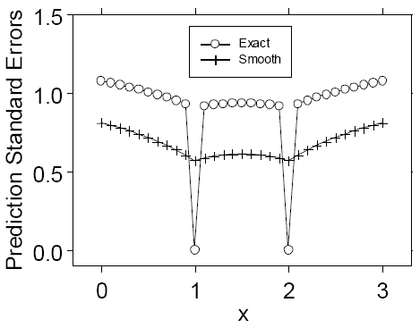
The effect of choosing measurement error models is that your final map can be smoother and have smaller standard errors than the exact kriging version. This is illustrated with an example in the figures below, where exact kriging and smooth kriging are shown when there are only two data locations (at 1 and 2) with values -1 and 1 for a model without measurement variation and one where the nugget effect is all measurement variation.


Vous avez un commentaire à formuler concernant cette rubrique ?